Waypoint overload

For everything Garmin Zumo 660/665 related
suzukizone
Posts: 24
Joined: Sun Nov 29, 2020 12:50 am
Been liked: 7 times
United States of America

Waypoint overload

Post by suzukizone »

Making progress learning to plot routes in Basecamp and run with my Zumo 660LM. One issue I am stuck on.

When I plot a route, I generate 20-30 waypoints as I run along the map in Basecamp clicking spots to build a continuous route. I then upload the route into the Zumo, import the route from "My Data" into my "Custom Routes" folder. The audio direx are fine, giving me all the twists & turns I plotted BUT I also have to listen to each and every waypoint along the way. The voice will state I am approaching such and such address in 0.2 miles for instance. Then as I get next to that spot the voice tells me I have arrived at the address on the left or right as the case may be. The plotted route and verbal instructions continue along until I begin to approach the next place I had clicked on the BAsecamp map and the process repeats.

So I do get the entire route read to me as I plotted it, beginning to end BUT have to listen to "Jack" blabbering about all these waypoints which I had set by clicking my route out, step by step.

There must be a way to pass the route over to the Zumo as a continuous and singular event and not a series of short runs that make up the whole. :roll:

Thanks for your continued support.

DH
MSTOCK27370
Posts: 196
Joined: Tue May 05, 2020 1:02 pm
Has liked: 13 times
Been liked: 29 times
United States of America

Re: Waypoint overload

Post by MSTOCK27370 »

suzukizone wrote: Fri Jan 15, 2021 11:51 pm Making progress learning to plot routes in Basecamp and run with my Zumo 660LM. One issue I am stuck on.
...........................................
So I do get the entire route read to me as I plotted it, beginning to end BUT have to listen to "Jack" blabbering about all these waypoints which I had set by clicking my route out, step by step.

There must be a way to pass the route over to the Zumo as a continuous and singular event and not a series of short runs that make up the whole. :roll:
DH
When you click on all of those points in Basecamp, you are creating Via Points. These all get "announced". What you need to do is change these Via Points to Shaping points, which are NOT announced.

Double click on the route in Basecamp, so it opens up and you see a list of all of the points. You should now highlight all of the points that you want to edit. Once they are highlighted, right-click the mouse and you will have an option to change them so they do not Alert On Arrival. If there are any that you want to have announced, set those points to be Alert On Arrival. Transfer this route to your Zumo. It should work.
Capture.JPG
Capture.JPG (51.25 KiB) Viewed 3807 times
Michael S.
Trinity, North Carolina
Zumo 590LM, 396LM, 550 BMW R1100RT, R100, R60/6
suzukizone
Posts: 24
Joined: Sun Nov 29, 2020 12:50 am
Been liked: 7 times
United States of America

Re: Waypoint overload

Post by suzukizone »

Thank you MSTOCK27370. I knew there was a way. I am about to plot a course or two & try your method. Not sure when but next day or thre I will take the Zumo out in car or on the bike to give it a shot. :D

Stay safe & healthy!

DH
sussamb
Posts: 1713
Joined: Mon Apr 23, 2018 1:06 pm
Has liked: 306 times
Been liked: 353 times
Great Britain

Re: Waypoint overload

Post by sussamb »

Note some older devices don't accept shaping or 'do not alert' points. I'm not sure if that applies to the 660/665 models though.
suzukizone
Posts: 24
Joined: Sun Nov 29, 2020 12:50 am
Been liked: 7 times
United States of America

Re: Waypoint overload

Post by suzukizone »

Thanks sussamb, well I built a small route of about 10 miles around the area and put in about 6 or 7 viapoints, and marked all but the start & finish for no announcement. Will try to break away from the avalanche of chore next day or two to test. Letcha know.

Stay safe.

DH
MSTOCK27370
Posts: 196
Joined: Tue May 05, 2020 1:02 pm
Has liked: 13 times
Been liked: 29 times
United States of America

Re: Waypoint overload

Post by MSTOCK27370 »

sussamb wrote: Sat Jan 16, 2021 8:02 am Note some older devices don't accept shaping or 'do not alert' points. I'm not sure if that applies to the 660/665 models though.
DH - I hope your route test is successful. I know that the Zumo 450 and 550 don't use Shaping Points the way they are used in Basecamp. Not sure if the Zumo 660 is affected by this. If your test works the way you wanted, then you are good to go. If not, then there is a workaround.

Just report back once you've made your test run.
Michael S.
Trinity, North Carolina
Zumo 590LM, 396LM, 550 BMW R1100RT, R100, R60/6
jfheath
Posts: 2199
Joined: Sat Oct 19, 2019 4:17 pm
Location: West Yorkshire, Uk
Has liked: 267 times
Been liked: 587 times
Great Britain

Re: Waypoint overload

Post by jfheath »

Basecamp has features which have been developed since the 660 was withdrawn. After that, Garmin observed that under certain circumstances, routes created with Basecamp may produce problems, and using Mapsource is more reliable.

The current concept of alerting and non alerting points did not exist for the 660, and although the terms shaping and via points were often used, they seemed to mean something different.

The term 'Waypoint' does not refer to a point on a route. It has always referred to a point that is created and saved for future use. Perhaps simply to have as a 'Favourite' in you zumo, in case you fancy going there. Or a previously saved Waypoint may be added to a route.

I have a few notes from when I owned a 660, I'll see if there is anything that will help. Its very difficult to separate what I know now from owning a 590, a 595 and an XT from what I knew when I had my 550 or 660. In many ways the 660 was the best of the bunch. I wish I still had mine.

32Gb is the limit for the 660 card. Internal memory is faster for maps, if they will fit. I just used my SD card for music. 8Gb was way more than I needed.

Map install used to have a feature where you could install selected areas of maps, I don't know if that is still available. That can help to reduce the amount of space taken up with internal memory.

Today, I discovered something really important. I found another way that doesn't work.
jfheath
Posts: 2199
Joined: Sat Oct 19, 2019 4:17 pm
Location: West Yorkshire, Uk
Has liked: 267 times
Been liked: 587 times
Great Britain

Re: Waypoint overload

Post by jfheath »

Ok I have discovered the notes I made at the time. I won't reproduce them here because they contain some assumptions which I now know to be incorrect but:

The 660 will accept Stored Waypoints either individually or as part of a route.
The 660 will also accept shaping points - points that are inserted into the route to force the route along particular roads, without having to name them first. In Basecamp, the 'Insert' tool is used. In Mapsource the option is obtained by right clicking the mouse on the route section where a shaping point is required.

So in the 660 the term Via Point is used to mean a Waypoint that has been used in a route. It is named, created with the flag tool and either added or the route is constructed automatically from the a list of selected Waypoints. Via Points in the Zumo will announce on arrival.

Shaping points have been created using the insert tool. These do not announce on arrival.

A Via Point in Basecamp and later zumos is slightly different. It too announces on arrival, but it does not have to have been created as a Waypoint. A shaping point can be made to announce on arrival. A Waypoint in a route can be made to be silent - it becomes a shaping point.

Looking at the gpx files that are created, I can see the problem with using Basecamp. Basecamp uses a specific tag for identifying Via Points. Mapsource does not. In fact if a Basecamp gpx file is loaded into Mapsource, Mapsource strips out the tags that relate to Via Points.

Best solution is to create your route by first creating the Waypoints. Then build the route using those waypoints - select the waypoints you want, right click and select 'Create Route Using Selected Waypoints'. If you use CTRL click to select each waypoint in turn - then this will create the route with the waypoints in the order selected, otherwise you have to reorder them to make the route that you want.

Then drag in you shaping points using the insert tool.

When your route is finished, double click the route name and from the list select all of the route points for the route except the start and end, right click and select 'Do not alert on arrival'.

Send that to the Zumo 660. You should end up with a route with all shaping points, but the ones that were created as waypoints will be recognised by the 660 and they WILL alert.

If you experience this weird behaviour mentioned by Garmin, then you will have to introduce another step. Export your route as a gpx file and load it into mapsource. Mapsource should pick up the same map as Basecamp, but check that is the one selected. Check the mode of transport is correct. Recalculate the route in Mapsource and send it to your 660 from there. It saves learning how to use Mapsource to create a route.

The 660 is the most forgiving of the Zumos. If you wander off the route and autorecalc is turned on, it will calculate a new route to take you to the point that it was trying to take you to next. But if you ignore that and rejoin the route AFTER the point that it trying to take you to, it will continue from that point onwards. It does this for any type of point - a ViaPoint/Waypoint as well as a shaping point.

If autorecalc is turned off, then the Zumo will go quiet until you rejoin the plotted magenta line

The later models - 590, 595 and XT will do this for non-alerting shaping points, but they all insist that you visit the alerting Via Points.

The most important thing to learn is that when reading replies or comments on forums about zumos basecamp and mapsource - the definition of a Via Point is slightly different, depending on the author's experience .... and whether or not they are using the term correctly in the first place. That is not intended as a put-down. There is no common dictionary of terms between routing programs and sat navs. For the 660, a Via Point is a Waypoint that was put into a route. For the later models it is a point which will alert on arrival.


Two things to note with the 660.
Never create a route that is a complete circle. It will stop navigating as soon as you set off, because you have reached the end.
If you make a figure of 8 route - make sure you know which road to take before you arrive at the crossover point. Suppose you start at the bottom of the '8'. At the point where the top loop and bottom loop meet there is a section of road that you will travel on twice. The ZUmo will initially direct you in the right direction, but if it thinks that you are on the 2nd visit to this road, it will quite happily take you on the route to complete the circle of the bottom loop, rather than take you onto the top loop. BUT - as soon as you realise, backtrack and take the route up to the top loop, it will continue navigating that correctly ! It doesn't care - it just keeps you on the magenta line ahead.
Last edited by jfheath on Sun Jan 17, 2021 7:38 pm, edited 1 time in total.

Today, I discovered something really important. I found another way that doesn't work.
suzukizone
Posts: 24
Joined: Sun Nov 29, 2020 12:50 am
Been liked: 7 times
United States of America

Re: Waypoint overload

Post by suzukizone »

Thanks guys for that incredible research and info from your experience. Will have to read it over a few times to fully grasp. Will also pass on to my friend, from whom I got the 660, so we can work together to hash this all out. He is also having some issues with this type of hangup.

Be safe.

DH
jfheath
Posts: 2199
Joined: Sat Oct 19, 2019 4:17 pm
Location: West Yorkshire, Uk
Has liked: 267 times
Been liked: 587 times
Great Britain

Re: Waypoint overload

Post by jfheath »

You may find it useful to observe what happens on a short test route.

Plan a short route near home from point A to point B - which is along a main road, but which takes short detours and then returns to the main road.
Something like this:
Test Route Diagram.jpg
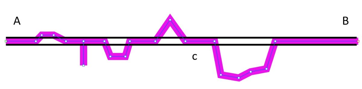
Test Route Diagram.jpg (22.36 KiB) Viewed 3736 times

The magenta line shows the test route. The black straight line shows the main road.
Make one of the detours stay very close to the main road - like a lay-by - just so that you can see the detour and the main road on the same screen.
Make another one be a short detour up a side street, and returning by the same route.
Make sure that you have route points to force the navigation back onto the main road after each detour.
Make some of the detours have more than one route point - eg the last one on my diagram has 4, and make some of them Waypoints/Via Points (created with the flag tool in Basecamp/Mapsource and some of them shaping points.

Don't worry where they are, or what the ride is like - you are going to completely ignore where the satnav tells you to go and ride along the main road !!

It might be useful to set up the 660 so that it displays the data view on the right hand side. Sorry, I can't remember how to do this on the 660, and the manual doesn't mention it. But you should be able to show Distance to End and Distance to Vias. Once you have the display on the right of the screen, you can touch any of the four data items and choose what data is displayed in it. Not important, but it might help, or you might want to leave that until alter.
garmin_zumo_660 Data View.jpg
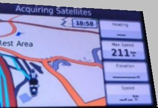
garmin_zumo_660 Data View.jpg (13.58 KiB) Viewed 3736 times
Turn on allow U turns. Turn off auto recalculate. Set off on the route but stay on the main road. Make sure that you can hear the satnav instructions, but ignore them. Watch what happens when you pass the first turn off point. And watch what happens when you see the magenta line appear on the screen up ahead.

You'll get the picture.

Then go back and do it again, this time with autorecalc turned on. This time you will have to be determined to ignore the instructions. Don't be tempted to turn the sound down. Try to understand what it is trying to get you to do, but take absolutely no notice of it - stay on the main road as before. And note what happens when magenta line appears back on the main road ahead, and you rejoin it.

The 'prompted' option for recalculating a route is obvious, but you might as well give that a go as well so that you know what it does.

-------------------------------

nb - don't be tempted to extend the route back to home until you have don the A to B test. It will confuse you - apart from the fact that it will stop navigating as soon as you set off - cos you are already at home. But in effect you will have two magenta lines - one going from A to B, and the last leg coming back along the main road. It is impossible to tell whether the magenta line on the screen is the one going to A or the one coming back. It is even more confusing when the satnav is telling yo to turn left up ahead, but you can see the (return) magenta line continuing along the main road.

Having said that you are bound to want to try it. So - if you do, have auto-recalc turned on, and make sure that the extra route point to get you back home is not placed at home. Place it a mile away. You can probably find your way back from there. This is to stop the 660 from telling you that you have finished the route as soon as you set off.

If you do this final test - place a Waypoint at about point C on the way back from B. As you are riding from A to point B, and after you have passed the location where you place the Waypoint at C, the bike will still be directing you to the next detour and then on to B. Stop, turn the bike round and head home. You will be heading back towards point C. What does the satnav do ? Tell you to go back to the detour that you were heading for and then on to point B or announce that you have arrived at Point C and continue navigating back home.

Then turn back and head towards point B as before. And note what the satnav does then. Does it try to take you back home, or will it take you up the next detour as you had towards B ?

This little exercise will teach you a lot about what the 660 is actually doing, so you won't be confused when it occurs when you are following an unknow route.

Today, I discovered something really important. I found another way that doesn't work.
Post Reply