semmyroundel wrote: Fri Aug 06, 2021 10:16 pm
jfheath: "and it never does anything that is unpredictable"
I'd have to take issue with that as it continually tried to make me do a U turn today that I knew was totally useless and would make my trip longer, just because I hadn't taken some routing advice (I had local knowledge that was better).
I was totally surprised what route it asked me to do.
Now - for me, that would not be unpredictable. If you ignore routing advice, it will try to calculate a new route to the next routing point (Via or Shaping). In some circumstances that might mean that it has to do a U turn in order to find the fastest or shortest route (depending which option you have set). Lets assume you have Fastest Time set (which is what the Zumo will default to using if the loaded route has a setting that it doesn't recognise).
There are three possibilities:-
Possibility 1) in going a different way you have missed out just a section of route without missing out any routing points.
In this case the satnav may well ask you to turn round and go back, because it reckons that it is faster to do that, than to continue the way that you are heading. If you ignore that, at some point the way that you are heading will be faster from your current position than it would be to perform a U turn. So it will start to navigate you ahead. and continue from there. All of the time it is trying to get you to the next route point in the trip.
Possibility 2) In going a different way, you will miss out a shaping point (shown on the map as a blue disc). So the magenta line is heading to the shaping point and your route is taking you to join the magenta route AFTER the shaping point.
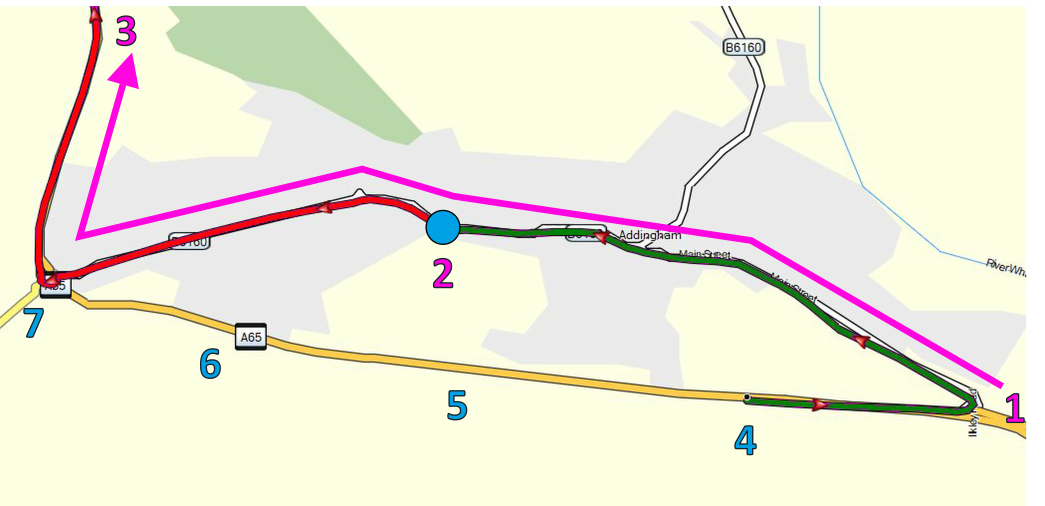
- Example 1b.png (290.88 KiB) Viewed 2349 times
See the example above. Click the image or right click to open it in a new window to get a clearer picture. I haven't found a way of preventing the forum from shrinking the displayed image. You are riding from right to left.
The plotted route is in the direction of the magenta line through points 1, 2 and 3.
Point 2 - the blue disc - is a shaping point.
The shortest and fastest route is to follow the line through points 1, 4, 5, 6, 7 and 3.
Ok - so you gnore the instruction to turn right at point 1 and ride towards point 4.
At point 4. The XT is asking you to make a U turn. The green route drawn is the fastest way to the shaping point - which is what it has been asked to do.
Up until
somewhere near point 5, the XT will still ask you to perform a U-Turn. It is still faster to go back to the junction at1.
After Point 5. The XT changes its mind. It is now looking to be faster to go ahead to point 7, and then back to Point 2. It goes quiet. You are heading in the correct direction on its new route.
At Point 6, it alerts you of the roundabout ahead and says In quarter of a mile take the 3rd exit at the roundabout. (UK roads, Clockwise around roundabouts). This may seem completely wrong - YOU know that the way ahead is to take the second exit in the direction of 3. But you have put shaping point 2 into the route, and you still haven't visited point 2, and its job is to take you there.
At point 7 The satnav is still expecting you to take the 3rd exit towards point 2. Its route is to take you from 2 to 7, then do a U turn and head back to the roundabout and then to point 3. This sounds stupid,but it is just following the plan in the trip.
You decide not to take the 3rd exit, but instead head off towards point 7. Rather than go back to 2.
The satnav doesn't bat an eyelid. It is quite happy with that. Why ? Because you have joined the magenta route, you are heading int he right direction towards 3. The fact that it hasn't taken you to point 2 is largely irrelevant now.
Why ?
Because point 2 is only a shaping point. When you were on the section of route leading to point 2, it had to try to take you there. Because you have joined the route AFTER point 2, and you are heading to the next point in the trip - it is happy about that. The point you have missed is only a shaping point.
Possibility 3)
Is exactly the same as Possibility 2. Except this time, the route point at Point 2 is a
Via Point.
The navigation system INSISTS that you visit a Via Point. The same thing would happen as described in Possibility 2. Except if you ignored the instruction at point 7 to take the third exit at the roundabout, heading to point 2, and instead went up the red road towards 3, it would ask you to a U turn and would then navigate you back to Point 2. The only way that you can get over this is by skipping the route point. By tapping the Skip button.
In fact, the XT will probably pop up a message to ask if you wanted to skip the next route point. It would normally** do this after you have ignored 2 instructions to try to get you to visit point 2. The reason that this doesn't happen in this case and in your case is that it does not seem to count U-Turns in its count of two instructions. In the case of this diagram, you ignored the instruction to turn right at point 1. You then ignored the instruction to take the third exit at the roundabout. It probably repeatedly nagged you to do U turns all the way past points 4, 5 and 6. These don't count. Once you have gone past 7 heading towards 3, you have reached your count of two, and it will probably then ask if you want to Skip the Via Point at 2.
Possibilty 4 (yes I know I said 3, but I've just thought of another.
The maps are wrong. You have taken a faster route that the satnav doesn't know about. Eg a new bypass that isn't yet on the map. Or a road that is on the map, that doesn't exist anymore. Ask
@rbentnail about this - his mapping is full of little roads that no longer exist.
Comment
** normally after 2 ignored instructions
That seems to be the norm, but I once counted 3, and on another occasion it stopped popping up a message. I wasn't paying enough attention to spot the circumsatnces, and it hasn't done it since.
This behaviour IS predictable. In fact I use it all of the time to plot my coffee stops. I put a shaping point where I might want to stop for coffee (eg at point 2). And then I will put a Via point which I know I will pass through whether or not I stop for coffee. (eg at Point 3). I then have the option to completely ignore point 2, and pick up the route after point 7, knowing that it will let me do this. If it isn't clear, I will put a Via Point at Point 1. Something that I created as a Saved Waypoint, and I will name it as "Right turn for coffee only". So that as I approach, I have an option - it will announce "Arriving at right turn for coffee Only".
I have to make this into a Saved Waypoint because since the 595, the XT changes the names of most route points to match its own database (possibly uses the lat/long coordinates to look up a name in FourSquare. Possibly not). Only points that were created as Saved Waypoints/Locations seem to be guaranteed to keep the name given to them.
semmyroundel wrote: Fri Aug 06, 2021 10:16 pm
But plus points: massive clear and bright screen, variable adventurous routing on the motorbike option, very quick go to data entry (my Tom Tom Go app can often not find destinations).
So good and bad, I'm learning to live with it.
I'm inpressed with it the more I get used to it. There are a couple issues which I believe to be bugs, but I have learned to live with them, since they have not yet fixed them.
Incidentally. Not many 3rd party mapping programs make any reference to Via Points and Shaping Points. Many of them don't have a clue about the oddities of points that were not created as saved locations/waypoints/favourites. MyRouteApp is the only one that I have come across that seems to be making steps to include vias and shaping points, but so far (Aug 2021) has not made any steps towards addressing the Waypoint Issue.
Basecamp for me is still the preferred mapping software it does everything that the Zumo does, and it uses identical maps to what is in the Zumo, so the Zumo doesn't have to calculate the route as soon as it receives it.
Autozoom
Settings->Map & Vehicle -> Autozoom
