Thoughts on "closest entry point"

Having Garmin zumo XT problems? there is loads of help and advice in this forum
jfheath
Posts: 2714
Joined: 19 Oct 2019 16:17
Location: West Yorkshire, Uk
Has liked: 351 times
Been liked: 749 times
Great Britain

Re: Thoughts on "closest entry point"

Post by jfheath »

I am certainly not going to shoot holes in your theories ! On the contrary I think that you are spot on in your deductions.

Thank you for those observations - it is good for me to revisit them - I haven't looked at it for a couple of years.

This was the first feature that I looked into when I got my first XT in April 2020. It arrived with software version 2.30 I think it was.
Very time I'd got a handle on exactly what it was doing, a new update came out and the behaviour of Closest Entry Point (CEP) changed !

I think that you are absolutely correct in deciding that the CEP is the point on the route which is closest to your current position. At least for the majority of the time.

You might be interested in a bit of history of how this feature changed - as observed in my various tests at the time, from system software v2,30 to v2.90
  1. CEP headed for the closest Via Point. I was most disappointed. It was just like starting the route and selecting next destination. It ignored all shaping points and headed for the next Via. If the only Via point in the rest of the route was at the end, it headed for that.
  2. CEP headed for the nearest Via Point OR any point that had been created as a Waypoint with the BC flag tool. So it would head for a shaping point, if a waypoint had been used and then set to not alert (shaping point).
  3. CEP headed for any via point or any shaping point. (I can only guess that perhaps someone explained 'waypoint' to the programmers).
  4. CEP headed for the nearest location on the route. This was v2.90 of the software.
I have never been certain whether or not the XT takes into account the actual distance to travel to reach its chosen point. I suspect not - as the XT seems to adopt various techniques to calculate a solution quickly. That is a legitimate reason - there is no point in calculating a superb solution if it doesn't pop up on the screen in time to leave the motorway !

In my tests I tempted the XT to head for a nearest Via Point or Shaping Point - but it didn't bite.

There were a number of odd situations - so it is always worth checking the preview map.
  • Facing the wrong way - the XT may come up with a solution based on which way it thinks you are facing.
  • U turns disabled - linked with the above. If it can't turn you round, it may come up with a very long, weird solution.
  • Positions where it is impossible to draw a straight line that meets the route at a right angle.
  • A position which is before the start but in line with the route eg being due south of a starting point of route heading north.
  • Round trip routes - it may find the route back home !
If you are interested in the tests that I carried out - I typed them up and illustrated them. In fact I have two versions - a more detailed one describing the tests and my comments as I carried the tests out. And the one attached which is still detailed, but made a bit slimmer. They were intended to be part if 'Zumo XT - Everything you need to know' but I decided against including these pages.
Attachments
Zumo XT - Missing Info - Original Closest Entry Tests.pdf
(1.55 MiB) Downloaded 246 times
Have owned Zumo 550, 660 == Now have Zumo XT2, XT, 595, 590, Headache
Use Basecamp (mainly), MyRouteApp (sometimes), Competent with Tread for XT2, Can use Explore for XT - but it offers nothing that I want !

Links: Zumo 590/5 & BC . . . Zumo XT & BC
smfollen
Subscriber
Posts: 57
Joined: 10 Jan 2024 20:31
Location: Boston Area
Has liked: 29 times
Been liked: 21 times
United States of America

Re: Thoughts on "closest entry point"

Post by smfollen »

@jfheath. Thank you for the reply and your testing details, which are certainly helpful. Chasing answers during the changing evolution by Garmin must have added to your fun!

I have taken some time to digest what you shared. If I understand them correctly, your results seem to be consistent with what I have found. I too have seen that CEP does head to the Magenta route line, not the closest via or shaping point. The U-turn related effect you point out is interesting. I normally allow U-turns, as your suggest, although I’m not sure it matters for the simple case I’ve offered here.

Please allow me to take this discussion a bit deeper. The magenta route line is, of course, made up of route points. When CEP heads toward the route line, I think, more precisely, the software calculations would require heading to one or more of the specific points which define the route line. That is consistent with what I’ve seen and with the information I received from Garmin support. For purposes of the CEP calculations, I believe it does not matter what type of point. Via, shaping and hidden points are all equivalent route points to be considered in the calculations.

I have refined my previous example route slightly and added some additional detail for clarity.

As before, I specified just two points, the start and end, which, of course, are both via points. There are no shaping points.
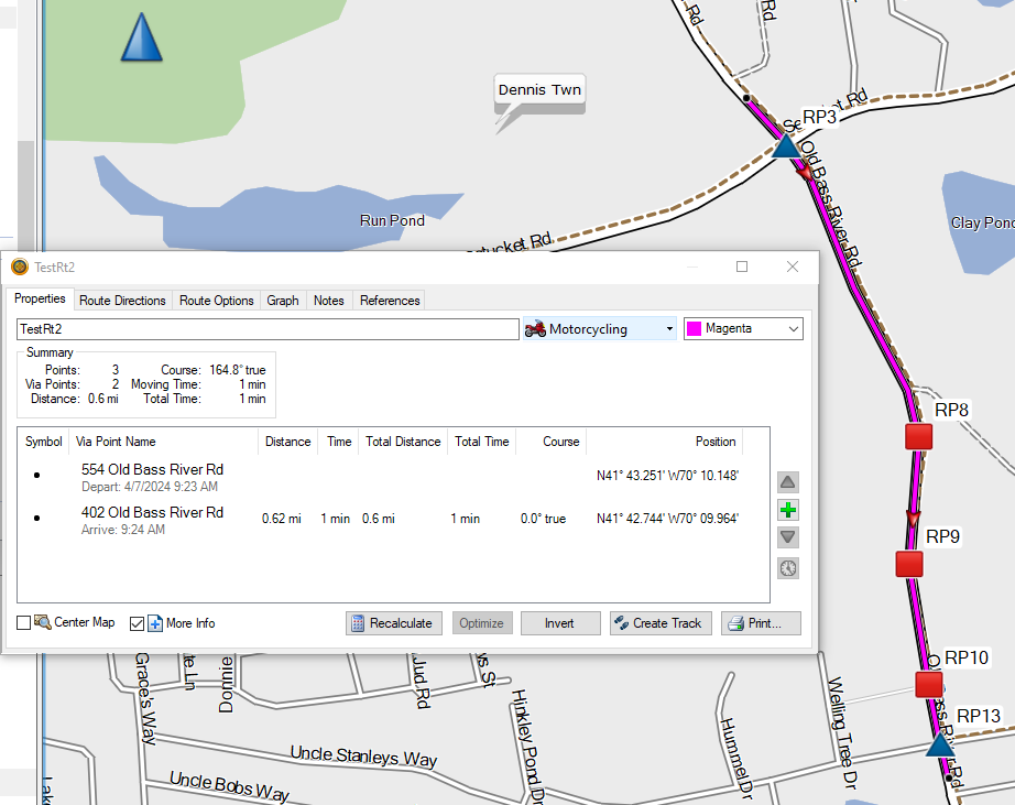
CEP2RouteDetail.png
CEP2RouteDetail.png (166.63 KiB) Viewed 665 times
(As a side note, “Points: 3” in Basecamp’s Summary display is yet another curiosity I’d like to chase down sometime in the future.)

Converting the route to a track indicates 14 / 15 track points (the last two are the same location), which implies that number of route points, with all but two being “hidden” or “ghost” points.
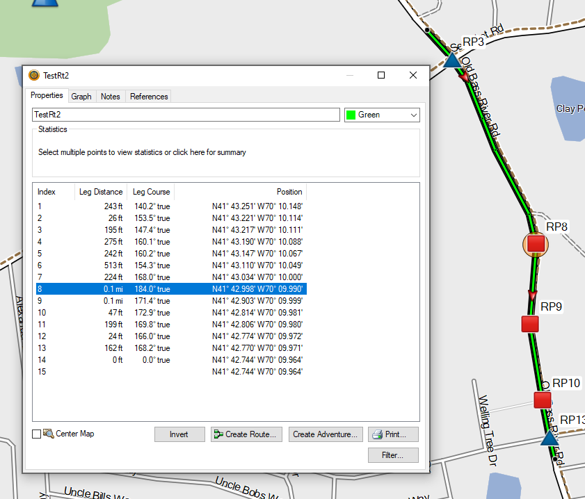
CEP2RoutePoints.png
CEP2RoutePoints.png (137.43 KiB) Viewed 665 times
As you can see, I have marked and labeled some of the hidden route points for clarity.

I’ve noticed that the routing calculations appear to put a hidden route point at every intersection and every point where the road changes direction. Further below it will become clear why I point this out.

I have also marked the two off route locations where the motorcycle rider might start the CEP process (green circles A and B).
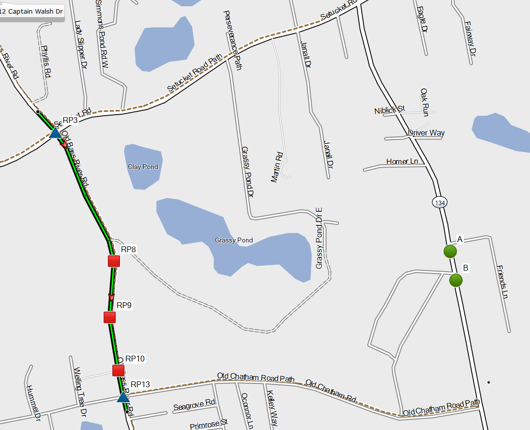
CEP_2_Base.png
CEP_2_Base.png (288.06 KiB) Viewed 665 times
From either A or B, there are only two [on road] locations where the motorcycle could join the route. Those are marked with the blue triangles at Route Points 3 and 13.
To the human eye (my eye at least), it appears that both A and B are closer to RP13 than to RP3, so I would expect CEP to go that way from either A or B.

As indicated in my previous post, CEP from B does route as expected, but CEP from A joins the route at RP3.

Do my eyes fail me? I am getting old! I checked and found that A is 1.1 miles from RP3 but just 1.0 mile from RP13 so my eye is correct, at least by distance over the road. As a further check, I created a route directly from A to RP13. The routing calculation on the zumo XT took the expected shorter route. I tried both Faster Time and Shorter Distance preferences. I routed from A to both RP13 and the end via point. In all cases, it took the expected shorter route.
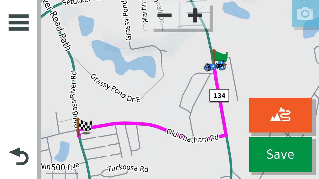
Route_AtoEnd.png
Route_AtoEnd.png (376.61 KiB) Viewed 665 times

So why does CEP from A take the unexpected longer route?
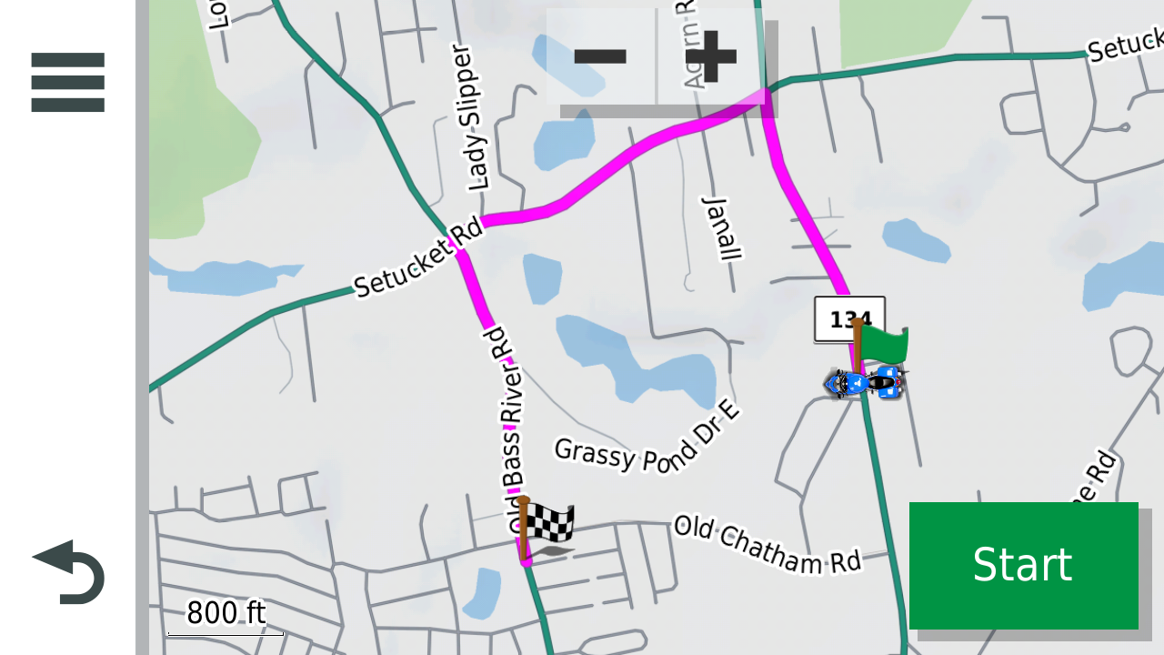
CEP2fromA.png
CEP2fromA.png (592.78 KiB) Viewed 665 times

According to my theory, it is because the closest route point to A is RP8 …
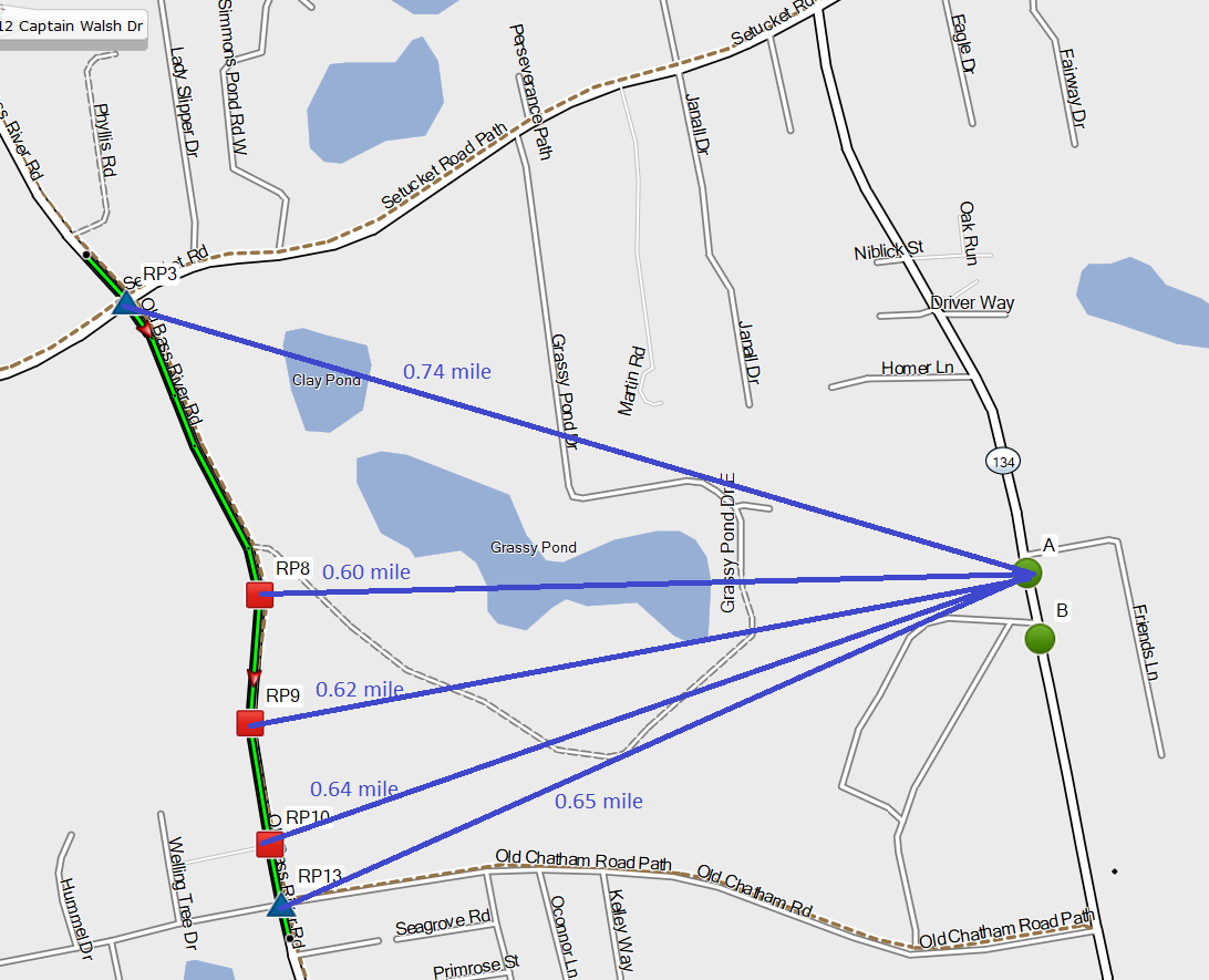
CEP_2_DistanceA.png
CEP_2_DistanceA.png (293.6 KiB) Viewed 665 times
… and the shortest route from A to RP8 is via Setucket Road.
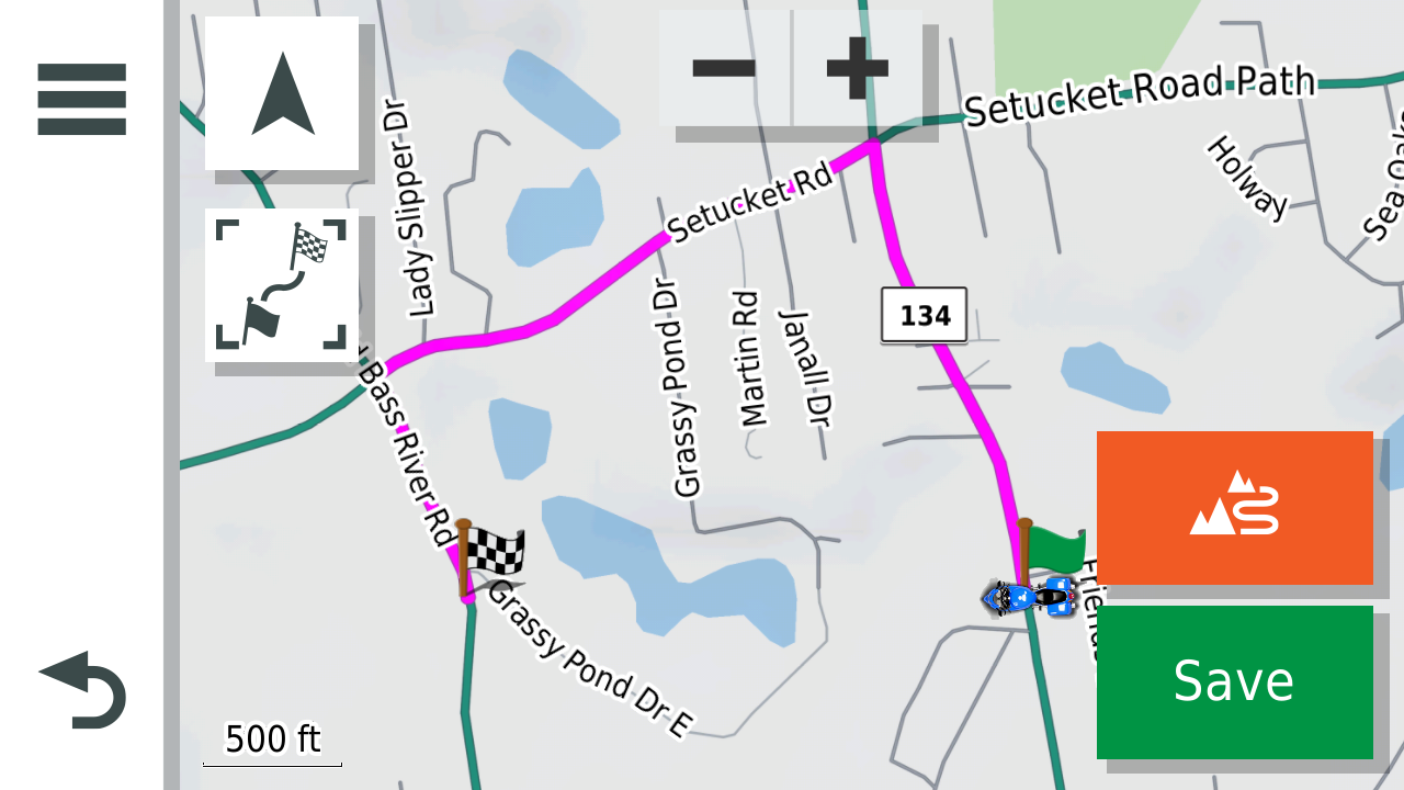
RouteAtoRP8.png
RouteAtoRP8.png (422.33 KiB) Viewed 665 times

I’ll explain further.

I think, like many other terms, “Closest Entry Point” is a bit of a misnomer. Again, there are only two possible actual entry points here, RP3 and RP13.
From A, the “Closest Entry Point” is RP3 even though RP13 is closer by time, road distance and “as the crow flies”.

What I believe the zumo XT is doing is not unreasonable. It’s just a matter of terminology, and computing efficiency. At the start of the CEP process, the zumo only “knows” the planned route and the current location (A). It needs to calculate an additional route from A to the planned route, which really means from A to a point on the planned route. Which point on the planned route? The Closest Entry Point of course, but it can’t know which point that is without calculating the route. It’s a bit of a “catch 22”. It can’t even know which route points are possible entry points without calculating routes.

Calculating routes from A to each point on the planned route would be a lot of work – that is a lot of compute power and time. So, how does the zumo decide what route to calculate? A reasonable approach would be to start with the much faster calculation of straight line (as the crow flies) distances from A to each route point. Some of those distances are shown above in the CEP_2_DistanceA screenshot.

Using that approach, RP8 is the closet route point to A. This gives the software a destination for the additional route calculation. The route from A to RP8 can now be calculated. That route is shown above in the RouteAtoRP8 screenshot.

The final step is to merge the additional route to the planned route. Since route calculations put hidden points at intersections, it is easy to determine that the two routes intersect at RP3.
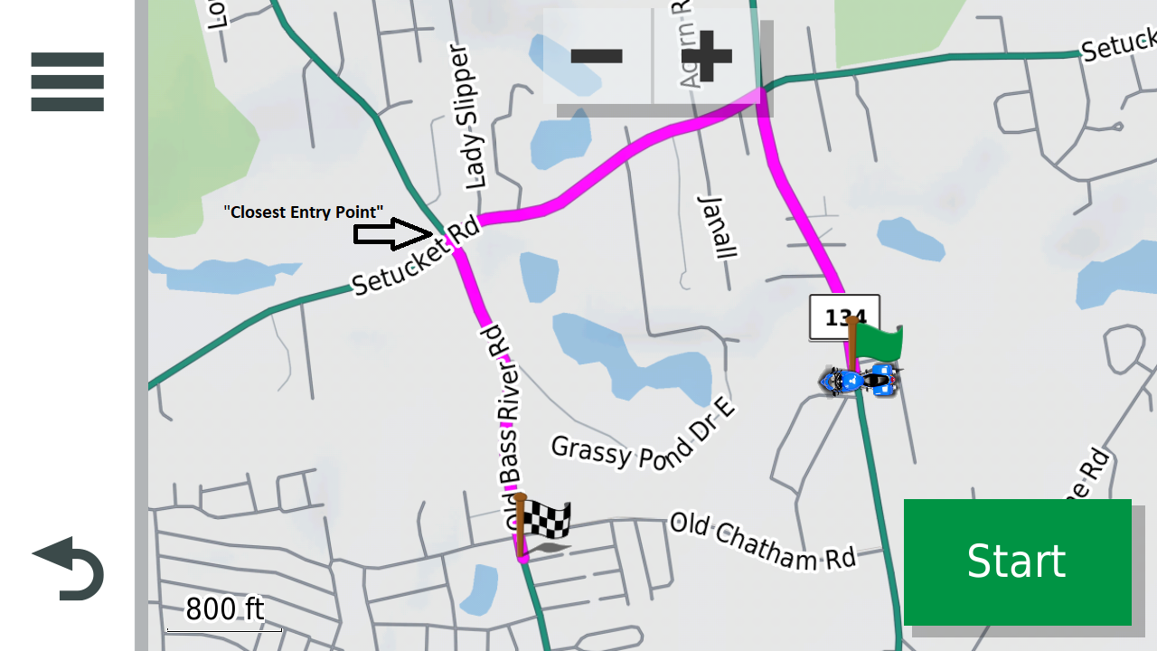
CEP2fromA_CEP.png
CEP2fromA_CEP.png (595 KiB) Viewed 665 times

RP3 becomes the “Closest Entry Point” (even though RP13 is closer to A by every reasonable measure).

If this theory holds, then the “Closet Entry Point” is the point where two routes meet.
The first is the planned route.
The second is a route calculated from the current location to the closet point in the planned route.
Closest point here means, from the set of via, shaping or hidden points which specify the planned route, the point which is the shortest distance, as the crow flies, from the current location.

As you have pointed out, there does appear to be a flaw when the current location is in line with the planned route. I’ll share a thought on that separately.
User avatar
Peobody
Subscriber
Posts: 1539
Joined: 20 Apr 2021 13:33
Location: North Carolina USA
Has liked: 113 times
Been liked: 336 times
United States of America

Re: Thoughts on "closest entry point"

Post by Peobody »

I used CEP earlier today. I had gone off-route to a department store. That store was north of my northwest-to-southeast planned route. When I left the store, I restarted the route and chose CEP. The calculated route brought me southwest to the route, joining the route at what was visually the closed point. There was a more efficient option of going directly south. The chosen option was on faster roads but the southern route would have been more efficient both in time and distance. So, one has to wonder whether the XT decided solely on closest point or whether faster roads played a part in the calculation.
2008 Honda GL1800 Goldwing
1995 Kawasaki ZG1000 Concours
zūmo XT linked to Cardo Packtalk Bold and iPhone SE.
jfheath
Posts: 2714
Joined: 19 Oct 2019 16:17
Location: West Yorkshire, Uk
Has liked: 351 times
Been liked: 749 times
Great Britain

Re: Thoughts on "closest entry point"

Post by jfheath »

Yes, I picked up on your - 'it heads to the nearest point of any sort' comment. I didn't say anything though.

Yes I think that must be correct. It doesn't have an equation for the line on which it can perform any maths. It just has the points and the very easy to calculate distance between the points.

The sections of road are marked with subclass information which relates to all sorts of things, some known, some assumed. Speed, road type, etc. It would be logical for it to add points where the road information changes.

I'm not sure that I ever decided how it worked out 'closest'. Is it closest by road or as the crow flies. Does it take into account speed limits, traffic, navigation preferences, historical riding data ? Observing the behaviour when navigating a track - and that dotted straight line to the closest point - it is tempting to believe that the same algorithm is used. But its difficult to prove anything, with so many variables. You can eliminate most variables by performing the tests with a newly reset to factory XT.

But.... there is one unknown that remains. The maps. The Zumo 590 used to use 'trafficTrends' - historic data which indicates the traffic flow at certain times and days of many of the roads. Since the 590 and the XT use the same maps, and seem to retain at least some of the same software - how do we know whether the XT's algorithms tap into that data. I suspect not, since it seems to abandon complexity to get the best answer for speed to get a quick answer that will do - in its calculations.

I'm curious and interested from a mathematical and logical point of view. But its not something I lose sleep over. However it does it, it locates a closest point on the route and calculates a route to it. And crucially, it can be any recorded point on the route ghost, via, shaping. If it happens to come across the route before it meets the point that it plotted, than that is good.

I used to think that it chose a point ahead ie in the direction of the route. But a few of my tests rejected that theory.

I don't think any of my tests were designed to find out how it did it - straight line, faster by road, shorter by road.
I would guess at straight line distance - then plot a route to that and let the normal routing algorithm deal with meeting the plotted route part way - ie it just joins it and follows it from there.
Have owned Zumo 550, 660 == Now have Zumo XT2, XT, 595, 590, Headache
Use Basecamp (mainly), MyRouteApp (sometimes), Competent with Tread for XT2, Can use Explore for XT - but it offers nothing that I want !

Links: Zumo 590/5 & BC . . . Zumo XT & BC
danham
Posts: 307
Joined: 13 Jul 2018 14:25
Location: Cape Cod, MA
Has liked: 99 times
Been liked: 94 times
United States of America

Re: Thoughts on "closest entry point"

Post by danham »

smfollen wrote: 07 Apr 2024 20:06 @jfheath. Thank you for the reply and your testing details, which are certainly helpful. Chasing answers during the changing evolution by Garmin must have added to your fun!

I have taken some time to digest what you shared. If I understand them correctly, your results seem to be consistent with what I have found. I too have seen that CEP does head to the Magenta route line, not the closest via or shaping point. The U-turn related effect you point out is interesting. I normally allow U-turns, as your suggest, although I’m not sure it matters for the simple case I’ve offered here.

Please allow me to take this discussion a bit deeper. The magenta route line is, of course, made up of route points. When CEP heads toward the route line, I think, more precisely, the software calculations would require heading to one or more of the specific points which define the route line. That is consistent with what I’ve seen and with the information I received from Garmin support. For purposes of the CEP calculations, I believe it does not matter what type of point. Via, shaping and hidden points are all equivalent route points to be considered in the calculations.

I have refined my previous example route slightly and added some additional detail for clarity.

As before, I specified just two points, the start and end, which, of course, are both via points. There are no shaping points.
CEP2RouteDetail.png

(As a side note, “Points: 3” in Basecamp’s Summary display is yet another curiosity I’d like to chase down sometime in the future.)

Converting the route to a track indicates 14 / 15 track points (the last two are the same location), which implies that number of route points, with all but two being “hidden” or “ghost” points.
CEP2RoutePoints.png

As you can see, I have marked and labeled some of the hidden route points for clarity.

I’ve noticed that the routing calculations appear to put a hidden route point at every intersection and every point where the road changes direction. Further below it will become clear why I point this out.

I have also marked the two off route locations where the motorcycle rider might start the CEP process (green circles A and B).
CEP_2_Base.png

From either A or B, there are only two [on road] locations where the motorcycle could join the route. Those are marked with the blue triangles at Route Points 3 and 13.
To the human eye (my eye at least), it appears that both A and B are closer to RP13 than to RP3, so I would expect CEP to go that way from either A or B.

As indicated in my previous post, CEP from B does route as expected, but CEP from A joins the route at RP3.

Do my eyes fail me? I am getting old! I checked and found that A is 1.1 miles from RP3 but just 1.0 mile from RP13 so my eye is correct, at least by distance over the road. As a further check, I created a route directly from A to RP13. The routing calculation on the zumo XT took the expected shorter route. I tried both Faster Time and Shorter Distance preferences. I routed from A to both RP13 and the end via point. In all cases, it took the expected shorter route.
Route_AtoEnd.png


So why does CEP from A take the unexpected longer route?
CEP2fromA.png


According to my theory, it is because the closest route point to A is RP8 …
CEP_2_DistanceA.png

… and the shortest route from A to RP8 is via Setucket Road.
RouteAtoRP8.png


I’ll explain further.

I think, like many other terms, “Closest Entry Point” is a bit of a misnomer. Again, there are only two possible actual entry points here, RP3 and RP13.
From A, the “Closest Entry Point” is RP3 even though RP13 is closer by time, road distance and “as the crow flies”.

What I believe the zumo XT is doing is not unreasonable. It’s just a matter of terminology, and computing efficiency. At the start of the CEP process, the zumo only “knows” the planned route and the current location (A). It needs to calculate an additional route from A to the planned route, which really means from A to a point on the planned route. Which point on the planned route? The Closest Entry Point of course, but it can’t know which point that is without calculating the route. It’s a bit of a “catch 22”. It can’t even know which route points are possible entry points without calculating routes.

Calculating routes from A to each point on the planned route would be a lot of work – that is a lot of compute power and time. So, how does the zumo decide what route to calculate? A reasonable approach would be to start with the much faster calculation of straight line (as the crow flies) distances from A to each route point. Some of those distances are shown above in the CEP_2_DistanceA screenshot.

Using that approach, RP8 is the closet route point to A. This gives the software a destination for the additional route calculation. The route from A to RP8 can now be calculated. That route is shown above in the RouteAtoRP8 screenshot.

The final step is to merge the additional route to the planned route. Since route calculations put hidden points at intersections, it is easy to determine that the two routes intersect at RP3.
CEP2fromA_CEP.png

RP3 becomes the “Closest Entry Point” (even though RP13 is closer to A by every reasonable measure).

If this theory holds, then the “Closet Entry Point” is the point where two routes meet.
The first is the planned route.
The second is a route calculated from the current location to the closet point in the planned route.
Closest point here means, from the set of via, shaping or hidden points which specify the planned route, the point which is the shortest distance, as the crow flies, from the current location.

As you have pointed out, there does appear to be a flaw when the current location is in line with the planned route. I’ll share a thought on that separately.
This is fantastic info -- many thanks. Because the routes you show in your screen grabs are approximately 5 miles from my home in Harwich, I have to ask an off-topic question: wanna do some riding one of these days?

-dan
Zumo XT, 660, nuvi 760 and many retired units dating back to the GPS III+
2018 Kawasaki Ninja H2 SX SE
smfollen
Subscriber
Posts: 57
Joined: 10 Jan 2024 20:31
Location: Boston Area
Has liked: 29 times
Been liked: 21 times
United States of America

Re: Thoughts on "closest entry point"

Post by smfollen »

Thanks Dan. I'm glad you found it helpful. It's only a theory, not proven. I will PM you about a ride.