Ok
I see the problem.
I think the route has not been recalculated after being loaded into Basecamp or into the XT, and I think that some shaping points may have been stripped out of the route on transfer. There don't need to be that many Via points - but it needs extra shaping points - which were probably there in the original route in Basecamp - but these have now gone.
I've attached a slightly modified route using the same points, but which still needs some attention.
All of this is described below.
----------------------------
At some point, I think that you have had the setting in Basecamp to avoid seasonal closures - but I cannot make my Basecamp miss out the cols that the route clearly does miss out. But when I recalculate the route those problems disappear.
When Basecamp receives a route, it accepts the exact route that it was given. It doesn't recalculate it. So when I opened up your route, it showed my that it would not go over the top at Croix de Fer, nor would it go past the lake at Mont Cenis. But as soon as I recalculate the route, it will gover over the cols. It behaves more like the route that you got by using the OSM maps.
I note that there are some missing Shaping Points in this route. - The Reason being that some points are visited for no reason using the same road to reach it and to travel away from it. The original route must have taken a different road to reach it. I am wondering if they have been deleted on Transfer by Basecamp, or whether this was the intention.
So just in case they have been deleted by accident - although why it would delete some and not others, I do not know:
Check Basecamp:
Edit -> Options -> Device Transfer
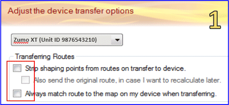
Make sure that none of the boxes are ticked. Apply to all devices.
Suggestions
- Select the route - right click to get the pop up menu and create a track from the route. (note that in the menu is an option to recalculate the route)
- Then select the route to openup the Route properties dialogue box. (That is a Double click the route on a PC - don't know about Mac)
- Click the Route Options tab
- Select Edit Profile
- Delete all avoidances - except maybe Unpaved Roads. (Make sure that your Zumo Navigation setting for motorcycle also avoids unpaved roads). There are a lot of tracks on the hairpin bends which Basecamp will take otherwise.
- Select Faster Time.
- Close the dialogue and let it recalculate the route.
When I transferred your route to my XT, it took forever, and then closed the XT without having completed.
I note that you have 29 Waypoint - all set as Via Points. 29 Via points is the limit that the Zumo can handle without splitting the route into two parts. I don't know if this is significant or not.
Your route is a 'there and back' route so you
MUST have some Via points otherwise the Zumo is likely to start leading you back before it has finished taking your there. But normally I would put Via Points only at places like coffee stops, or places that I want to have the distance/time displayed on the Trip Data down the right hand side of the Zumo in landscape view.
I've edited the route and selected some of the col waypoints to be Via Points. The rest I have made into shaping points. On Basecamp I have made the shaping points blue dots, the Via points are red flags. (that is similar to how the XT will display them - light blue discs and orange flags).
I notice that in some places, where the recalculated route goes, it follows the dual carriageways / motorways. eg the A32 heading east to SR25 Suza
You might need additional shaping points to control that.
Also, descending La Col de la Croid de Fer - the route takes the D80 rather than the main D926. The 926 follows the river, the D80 (or D808) must be higher up the valley sides, but is narrow, and from StreetView may not be the road that you want. Take a look.
Important :
Delete your existing routes from the XT. (You don't want any routes witht he same name confusing things).
Connect the XT to your computer using the USB cable
Delete your previous routes of the same namefrom the XT SD card.
Transfer the correct route to the Zumo XT. Also transfer the track.
See if that works.
You can display the track and the route on the XT screen at the same time. To do that, see this link here:
app.php/ZXT-P57
Note that P57 deals with XTs that have not set up EXPLORE.
The P58 deals with XTs that have set up EXPLORE.
Note: When the XT receives a route, it does not re-calculate it - unless it has to.
It has to recalculate the route if the map that was used to create it on Basecamp is not the identical version as the map that is on the XT. This is why your OSM maps are showing the correct routing over the cols.
You can force the XT to recalculate after importing the route, and loading it by changing the vehicle to car, and then back to motorcycle - when you first load the route and before you say Go!
You have your start point at your hotel. This is not a good idea. Place the start point on the road that you want to be on after leaving your hotel.
Otherwise, if your motorcycle is located in front of the start point, the satnav will want to take you to it, and it will spend the rest of the trip trying to take you back there.
The attached file uses the Motorcycle profile, is set to Faster Time. It has the same waypoints, but only 5 of these are set as Via Points. The others (except the start and the end) are all set as non-alerting Shaping Points.
I didn't use any avoidances, so without extra shaping points, it takes some short cuts which are not tarmac roads. It also takes dual carriageways - which I can see were not the intended routes.

