XT Routes & Trips

Having Garmin zumo XT problems? there is loads of help and advice in this forum
User avatar
lkraus
Posts: 342
Joined: Mon Aug 24, 2020 2:36 pm
Location: Central Ohio
Has liked: 49 times
Been liked: 110 times
United States of America

Re: XT Routes & Trips

Post by lkraus »

The "routes" appear to be recorded tracks with points mislabeled (by Garmin standards) as route points rather than track points. It seems to have been recorded by an app called Gaia. They are not in any kind of sequence and the "copy" files are not copies, they are actually unique paths. I've tried several ways to combine, join, convert, or optimize the mess and have not found any easy way to fix them.

If I really wanted to take the time, I would suggest this:
Load the gpx in Basecamp. Create a new route in that folder using Motorcycle or Driving mode. Just place the start and end points - it will be very much off course, but you will fix that. Change the new route to a color that contrasts with the old "routes". Drag the route with the "Hand" tool until it completely overlays the old track. Just grab it in the middle and drop it on the old track, then do the same with the halves on either side, and just keep putting it in the right positions. I find this easier if I do NOT need the Alt key for the move, see Edit>Options:
alt.jpg
alt.jpg (18.99 KiB) Viewed 138 times
.

When you cannot see any of the old color, open the new route (double-click the name). Put a check in the box in the lower left corner to "Center Map". then click each route point in sequence to be sure it is properly placed on the road. Fix the errors.

With the errors corrected, click the "Create track" button at the lower right.

EDIT: More to come, I hit submit unintentionally....
Last edited by lkraus on Fri Apr 05, 2024 4:51 am, edited 3 times in total.
____________________________________
2006 R1200RT
Galaxy S10<>Zumo XT<>Sena 20S
User avatar
lkraus
Posts: 342
Joined: Mon Aug 24, 2020 2:36 pm
Location: Central Ohio
Has liked: 49 times
Been liked: 110 times
United States of America

Re: XT Routes & Trips

Post by lkraus »

At this point you can just use the new track as it is, as long as you are willing to follow the line on the Zumo without navigation instructions.

The new route will be unusable with this quick and dirty method. Most of the newly created points will be alerting via points that will be announced several times as you approach and arrive, driving you absolutely crazy. Also, as you've already seen, the Zumo will split up a route of more than 30 via points into smaller routes. There are ways to edit the route (moving the via points to better locations, converting via points to shaping points) but they are probably not worth the effort.

Rather than perform extensive editing to fix the new route, I would get navigation instructions by converting the track to a Trip (https://www.zumouserforums.co.uk/app.php/ZXT-P53) and display both the track and the trip simultaneously (https://www.zumouserforums.co.uk/app.php/ZXT-P50).
____________________________________
2006 R1200RT
Galaxy S10<>Zumo XT<>Sena 20S
User avatar
Peobody
Subscriber
Posts: 1334
Joined: Tue Apr 20, 2021 1:33 pm
Location: North Carolina USA
Has liked: 99 times
Been liked: 277 times
United States of America

Re: XT Routes & Trips

Post by Peobody »

I did almost exactly what @lkraus described in creating a partial new route in Basecamp except I started at one end. One thing I didn't think to do was to change its route preference to "Curvy roads". I think this might have reduced the tendency of Basecamp to route over primary roads. I had 39 point in the 152 miles that I produced so I estimated there would have been around 100 in the total distance. @lkraus is correct in that they were all created as alerting points. Creating a track and then converting that to a trip is something I would not have thought of. I would have spent the time converting points to non-alerting during the process of checking placement precision.
2008 Honda GL1800 Goldwing
1995 Kawasaki ZG1000 Concours
zūmo XT linked to Cardo Packtalk Bold and iPhone SE.
colirv
Posts: 152
Joined: Mon Dec 30, 2019 9:38 am
Location: Tyne & Wear
Has liked: 41 times
Been liked: 35 times
Contact:
Great Britain

Re: XT Routes & Trips

Post by colirv »

I'd have simply "rubber-banded" to junctions.
Colin
BMW R1250RS
User avatar
Peobody
Subscriber
Posts: 1334
Joined: Tue Apr 20, 2021 1:33 pm
Location: North Carolina USA
Has liked: 99 times
Been liked: 277 times
United States of America

Re: XT Routes & Trips

Post by Peobody »

colirv wrote: Fri Apr 05, 2024 2:35 pm I'd have simply "rubber-banded" to junctions.
Good thought. Unfortunately, there are so many route points on the route being duplicated that there is one at almost every junction. A rubber-band click on an existing route points adds it to the new route instead of creating a new point. Avoiding that is a challenge in itself.
2008 Honda GL1800 Goldwing
1995 Kawasaki ZG1000 Concours
zūmo XT linked to Cardo Packtalk Bold and iPhone SE.
jfheath
Posts: 2280
Joined: Sat Oct 19, 2019 4:17 pm
Location: West Yorkshire, Uk
Has liked: 281 times
Been liked: 614 times
Great Britain

Re: XT Routes & Trips

Post by jfheath »

I haven't read the thread through - sorry. Just noticed the commentin the above post.
You can join multiple routes together in Basecamp


In Basecamp

Select the routes in the order that you wish to link them- do this by clciking the first and then holding down the conrol key and clicking each of the next routes in order.

With all of the routes selected, right click on any one of the selected routes and select "Join the Selected Routes" from the pop-up window.
A dialogue box appears listing the routes in the order that was selected - it gives you the option to reorder them.
Click OK

Do it with a few simple routes first - I believ that it takes the first route and joins the beginning of the second route to the end of the first. Make sure that your routes are plotted in the direction that you think that they are.

Today, I discovered something really important. I found another way that doesn't work.
User avatar
Peobody
Subscriber
Posts: 1334
Joined: Tue Apr 20, 2021 1:33 pm
Location: North Carolina USA
Has liked: 99 times
Been liked: 277 times
United States of America

Re: XT Routes & Trips

Post by Peobody »

Just as an FYI John, the downloaded .gpx file contains around 50 individual routes When placed in a List Folder, the map displays a contiguous line but the individual routes are not named in any way from which a sequence can be derived. Worse, many contain the word "copy" in their name but @lkraus has determined that they are not. The download .gpx is truly a mess from my limited cognition of satnav devices and mapping software (XT & Basecamp). If fascinates me that any device can navigate from that file.
2008 Honda GL1800 Goldwing
1995 Kawasaki ZG1000 Concours
zūmo XT linked to Cardo Packtalk Bold and iPhone SE.
User avatar
lkraus
Posts: 342
Joined: Mon Aug 24, 2020 2:36 pm
Location: Central Ohio
Has liked: 49 times
Been liked: 110 times
United States of America

Re: XT Routes & Trips

Post by lkraus »

FWIW, I did manage to make a temporary route overlaying the original "route" (track) files, convert the new route to a track and then made the new track available to @HMA14.

For the curious, the new gpx will be available in my DropBox for a few weeks: Vman Trail East to West.gpx

For the curious across the pond that want to see what happens when you try to join the mess of original routes, the OpenMapChest.org .gmap file of the U.S. works well in BC. It is free when downloaded with a torrent client.

There were three areas where I could not force the route to follow the original tracks in BC with the City Navigator map. Using an OSM map, Google Maps, and Street View, I found that one segment was gated at either end. Another segment appeared to be an abandoned alley way, now part of a few backyards. The third dirt road section of about 1/3 mile is present in the OSM map, is missing in CN, and curves in a different direction to a railroad right-of-way according to Google Maps, but the Street View shows a dirt road at about the right spot as the original tracks??? I included that segment as a separate track if HMA14 is feeling adventurous.
____________________________________
2006 R1200RT
Galaxy S10<>Zumo XT<>Sena 20S
jfheath
Posts: 2280
Joined: Sat Oct 19, 2019 4:17 pm
Location: West Yorkshire, Uk
Has liked: 281 times
Been liked: 614 times
Great Britain

Re: XT Routes & Trips

Post by jfheath »

Sorry for being a bit slow on reading through this.

OK - I now understand the problem and think I have a solution without using 3rd party stuff. Just Basecamp.

My Basecamp trick from my previous post works - but I hadn't realised that there were so many sections all in the wrong order and badly named.

Nevertheless in Basecamp, if you have all of the routes in the same List, then you can start at the Eastern side and click a segement. Then hold down the SHIFT key and select the next segment - that multi-selects each segment in turn in the correct order. Some segments are very short and easy to miss.

But that works, and you can then right click select the option to join all route segments together. Result: one complete route.

Except there is a problem. There are a few short sections that are plotted in the opposite direction to the rest. (not to mention the obstructions that @lkraus has identified)

So I joined the route together in 4 stages. The rogue reversed section is the yellow section in the map below.

Joined Routes.png
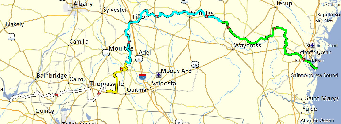
Joined Routes.png (592.63 KiB) Viewed 100 times

Ok - so I inverted the yellow section and then converted all route points except first and last to shaping points and then joined these together to make a complete route.

The route has 6853 points for 392 miles - clearly derived from a track. That is one point per 100 yards on average. Ridiculous.

Basecamp cannot reduce the number of points in a route, but it can reduce the number of points in a track using the filter option and setting a maximum number of points. The track can be converted back to a route in Basecamp.

So I created a track from the new long route, limited the number of points and converted it to a rute.

And that's where I stopped. Because I'm in the UK and only have Basecamp Global maps, the route is plotted as direct- very short straight sections - which is what a track is. When I convert the long route to a track, limit the number of track points, then cnvert that to a route - I have no way of seeing how effective that is at ensuring that the calculated route is plotted on the correct roads - because I don't have the USA maps.

But even reducing it to 393 points would plot an average of 1 point per mile. Its still a lot, but how far off route can it go?

Personally I'd try for 20 points and then tweak it manually to follow the line of the track.


Actually, given the steps involved Simply building a new route by following the line on the map would be qucker - as has been suggested already. I'd never used the join route option before. I wanted to see that it was possible without having to export and import.

I'll get the free map that @lkraus pointed to. (Thanks Larry). It will be handy for future. I miss not being able to download the free OSM maps when I need them.

Today, I discovered something really important. I found another way that doesn't work.
HMA14
Posts: 10
Joined: Mon Apr 01, 2024 10:04 pm
Been liked: 4 times
United States of America

Re: XT Routes & Trips

Post by HMA14 »

Thanks. I guess I'll have to do it that way.....
Post Reply