Page 3 of 3
Re: Rookie questions
Posted: Fri Nov 08, 2019 10:46 pm
by rbentnail
jfheath wrote: ↑Thu Oct 31, 2019 10:41 pmThere's one thing you mention about the 595 which i didn't know. You say it asks if you want to skip. The 590 doesnt ask. It will always try to go back to a missed shaping point - but it will skip the shaping point anyway.if you ignore the nagging and pick up the magenta route that is plotted after the shaping point. Via points continue to nag on the 590 until you manually tap the skip button.
I've not found a consistent reasoning for it. At first I thought it was me but by having all my routes the exact same way (start, destination, all points in between are shaping, non-announced points) I think I have eliminated me from the list of variables. But still, sometimes the 595 tries to constantly have me u-turn and sometimes it asks if I want to skip a point. Other times I have to pull up the menu for the skip button. Still other times I have to pull over, exit the rout then re-start the route in order to continue on. Otherwise the 595 would find itself in a watery grave in a roadside ditch. The randomness of it is very annoying.
Re: Rookie questions
Posted: Sat Nov 09, 2019 5:26 pm
by jfheath
It won't be random, but it will certainly seem like it.
I think I can help with getting you to understand this behaviour - 'cos I tore my hair out when I first bought the 590 when it did something very similar. Once I had changed my opinion about what it SHOULD be doing (based on what the 660 did), I was able to start learning what it was ACTUALLY doing, and why I was getting confused by it.
Now - because I know what it is doing and when, I can decide when it is safe to skip a point and when I need to ignore the nagging to go back. My hair isn't growing back, but I am now back in charge.
If you think it would help, I'll see if I can put together a pdf with pics that may well help. And I will make a guess at when the 595 prompts you to skip a point. I'll send you a link when I have done it.
Re: Rookie questions
Posted: Mon Nov 11, 2019 3:55 am
by CollingsBob
I’ve created my route(s) labelled them by number and by start and end point..1 per day. I am mostly happy with all except one - the Edinburgh to Inverbeg route which is day 1.
I would gladly trade scotch for assistance..I live in fear of arriving in Scotland only to find out that nothing works.
Re: Rookie questions
Posted: Mon Nov 11, 2019 12:09 pm
by jfheath
CollingsBob wrote: ↑Mon Nov 11, 2019 3:55 am
I would gladly trade scotch for assistance..I live in fear of arriving in Scotland only to find out that nothing works.
PM sent. Scotch is oh so tempting, but that isn't the motivation behind the offer of help !!
Re: Rookie questions
Posted: Tue Nov 12, 2019 5:13 pm
by 1200GSZumo
I'm attempting to 'piggy back' into this thread with my own rookie question:
I'm relatively new to Basecamp but have been using Garmin for quite a while, formerly with a Nuvi 550 and more recently with a Zumo 396.
My question stems from a recent experience after developing a route using Basecamp (of course based on the up to date maps from my Zumo) which led me here:
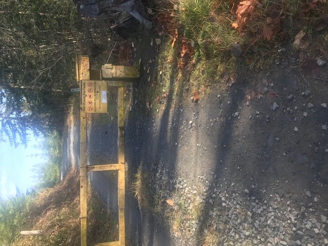
- IMG_3356.JPG (95.75 KiB) Viewed 3286 times
When developing the route there was no indication on the mapping that I was on anything other than a public roadway (albeit an unpaved one). In fact, the map display in Basecamp showed the road with a name which I took to be a reasonable indication that it was a public road. Fortunately, I was only out for a day ride and had hoped to use this route to enter into some national forest land and onto some unpaved forest service roads in a loop that would eventually return me home.
Is there some clue in the maps or Basecamp mapping that I missed that might have indicated I was headed onto a road that clearly was not open to the general public?
This experience makes me believe that perhaps one can't rely solely on the GPS/Basecamp map display when attempting to plot an off-tarmac route. It would seem that the ability to establish a route with waypoints doesn't guarantee that the means for navigating through those points is actually available via public roads.
Re: Rookie questions
Posted: Tue Nov 12, 2019 9:11 pm
by jfheath
What maps are you using ?
I haven't come across that sort of problem myself, but the early maps caused all sorts of problems with people ending up stuck in fields, driving over the edge of a cliff (allegedly) and things like that.
I loaded up the OSM maps for the UK recently, and noticed that the maps had lots of tracks and footpaths on. I tried to force the satnave to navigate onto a footpath - but it wouldn't do it. Then remembering that many walkers use Garmin products, and Basecamp is designed for them too, I set my profile to 'Walking'. Then Basecamp would quite happily stick to the marked footpaths - which could be really quite useful for other purposes.
I would guess that it is the profile name that makes the difference. It is the profile name that gets transmitted to the Zumo although it recognises only motorcycle, car and off-road. I haven't tried transmitting an off road route - I think it only draws straight lines, but can't be sure.
Answer is I don't know. But knowing what map you are using, and whether the identical map is used in BAsecamp and in the Zumo would certainly be a start. Other than that it looks like you have found an error on the map.
Re: Rookie questions
Posted: Tue Nov 12, 2019 10:13 pm
by rbentnail
Depending where you are, "it" happens all the time. In west-central and western North Carolina state and federal lands this is a constant issue. I often come across giant signs like "YOUR GPS IS WRONG" and "PRIVATE PROPERTY- GO BACK". It's not that you can't trust the mapping, it just means you have to become adept at routing on the fly. Especially when roads have changed, such as the dam installed 15 miles from me. Both Google and Base Camp suddenly think peoples' driveways are public roads. Lots of "GO BACK" signs in that area still and it's been nearly 10 years!
Re: Rookie questions
Posted: Fri Nov 15, 2019 12:46 am
by Breezly
"This experience makes me believe that perhaps one can't rely solely on the GPS/Basecamp map display when attempting to plot an off-tarmac route. It would seem that the ability to establish a route with waypoints doesn't guarantee that the means for navigating through those points is actually available via public roads."
You are absolutely correct. The navigation from any device is going to be limited by the underlying map data and when you get to off pavement roads it is in some places notoriously unreliable. Using topographic maps, NSF maps, local atlases and gazateers and Google Earth to verify the roads will help but are no guarantee either. The best assistance is local knowledge.
Rookie questions
Posted: Fri Nov 15, 2019 1:28 pm
by Iris
For off road, I use a smattering of media. I use BaseCamp along with Google Earth. However those two are not enough.
I have googled many forums that have downloadable gpx files and others that have a database full of off road routes.
They often have descriptions and photos and even videos of the terrain.
Even so, I have still come across a dirt road that has a closed gate across it. Sometimes the gates are seasonal.
None of this is the fault of BaseCamp.
There is no way that BaseCamp would be able to indicate which gates are open at which times. This would be a giant undertaking.....if not impossible.
Sent from my iPhone using Tapatalk
Re: Rookie questions
Posted: Fri Nov 15, 2019 9:40 pm
by rbentnail
One other thing I like to do when I come across a gate like this is to tap my vehicle icon and save where I am at that moment. With the coordinates I can go to my.garmin.com and report a map error. Hopefully someday it'll get fixed.