Zumo XT: route miscalculation after update

Having Garmin zumo XT problems? there is loads of help and advice in this forum
er-minio
Posts: 14
Joined: 02 May 2022 17:57
Location: London
Has liked: 3 times
Been liked: 1 time
Great Britain

Zumo XT: route miscalculation after update

Post by er-minio »

Hi all, first post here.
I've been lurking long enough though. :D

I have a Garmin Zumo XT. Had a series of (usual) issues, generally solved.
Last week it automatically updated to 6.4.0.
This brought the well documented "three dots menu" bug, so I proceeded to factory reset the unit.

Now, a couple of days ago I did a short route to test the XT as I'll be traveling soon and wanted to be sure it worked correctly (doesn't always do).

I planned a simple, short, loop in Basecamp. On the same maps as the unit (2022.2).
Uploaded to the device. Then navigated to the start of the route.

When approaching the start of the route it gave me an error (no traffic allowed) and was then unable to complete the navigation to the start of the route.
No biggie. I stopped navigation and restarted the route selecting closest entry point.

From now on, it worked sort of ok.
You can see the screenshot with the correct route and all, but every time I stopped (I moved about 10 meters off the road in the first instance, and about 30 meters in the second instance) the XT would mess up the route. See the pictures with the straight lines.
It would then recalculate it correctly after restarting the ride, but it takes a little while and if this happens when you stop at a junction or something similar, you won't know where to go.

I can provide the .gpx file if needed.

Trying to understand why this happens.

Correct rute:
Image

Miscalculations at entry point:
Image

Miscalculations when stopped/pausing along the route:
Image

Image

Thanks.
rbentnail
Subscriber
Posts: 929
Joined: 18 Jun 2018 10:14
Location: North Carolina USA
Has liked: 101 times
Been liked: 220 times
United States of America

Re: Zumo XT: route miscalculation after update

Post by rbentnail »

This is the primary reason I quit planning loop rides in one route. The 595 I was using would go pretty stupid like this, the XT is even worse. I now make one route for out, another route for back.
Russ B. Zumo 595 & XT
2007 & 2013 USA Yamaha FJR1300A
er-minio
Posts: 14
Joined: 02 May 2022 17:57
Location: London
Has liked: 3 times
Been liked: 1 time
Great Britain

Re: Zumo XT: route miscalculation after update

Post by er-minio »

It is not an exact loop.
I meat it was a loop for me, but the route has two different start/end points.
jfheath
Posts: 2654
Joined: 19 Oct 2019 16:17
Location: West Yorkshire, Uk
Has liked: 342 times
Been liked: 731 times
Great Britain

Re: Zumo XT: route miscalculation after update

Post by jfheath »

Welcome, @er-minio.

Post the gpx file please.

I'll need answers to the following as well, please.

What avoidances are set in the Zumo when it is in motorcycle mode (ie not car, not offroad). No route active.
What routing preference is set ( shorter, faster, etc) when the Xt is in motorcycle mode ( No route active)

What maps are ticked in MyMaps.

I am thinking that you maybe have an avoidance ticked and with so many shaping points you are forcing the route along roads that it isn't allowed to take.

The straight lines - that could be as a result of misplaced points or incorrect maps selected.

I'll be able to say more when I see the gpx file. Don't modify it before you send it please !
Have owned Zumo 550, 660 == Now have Zumo XT2, XT, 595, 590, Headache
Use Basecamp (mainly), MyRouteApp (sometimes), Competent with Tread for XT2, Can use Explore for XT - but it offers nothing that I want !

Links: Zumo 590/5 & BC . . . Zumo XT & BC
er-minio
Posts: 14
Joined: 02 May 2022 17:57
Location: London
Has liked: 3 times
Been liked: 1 time
Great Britain

Re: Zumo XT: route miscalculation after update

Post by er-minio »

Hi, thank you.

You can download the .gpx here.

I can check the settings and avoidances tomorrow morning!
But it would be the default motorcycling settings, as it was fresh from the hard reset.
er-minio
Posts: 14
Joined: 02 May 2022 17:57
Location: London
Has liked: 3 times
Been liked: 1 time
Great Britain

Re: Zumo XT: route miscalculation after update

Post by er-minio »

jfheath wrote: 02 May 2022 22:10
What avoidances are set in the Zumo when it is in motorcycle mode (ie not car, not offroad). No route active.
What routing preference is set ( shorter, faster, etc) when the Xt is in motorcycle mode ( No route active)
Hi @jfheath, on the Zumo:

Calculation Mode
Faster Time

Avoidances
U-Turns, Car Share Lanes, Unpaved Roads.
er-minio
Posts: 14
Joined: 02 May 2022 17:57
Location: London
Has liked: 3 times
Been liked: 1 time
Great Britain

Re: Zumo XT: route miscalculation after update

Post by er-minio »

I'm going through your guide in the meantime. Didn't see it before.
Rofor
Posts: 165
Joined: 19 Jul 2020 08:38
Has liked: 148 times
Been liked: 62 times
Austria

Re: Zumo XT: route miscalculation after update

Post by Rofor »

In the second screenshot - isn't that blue sign a 'closed road' sign? Did you have activated 'Traffic services' with the Garmin Drive App?

For me it looks similar to the (at least in Europe) known calculation bug after a full closure of an road used by the actual route! A similar problem happen to me last year in southern tyrol.

'Traffic services' through Garmin Drive app was used, route recalculation was set to 'on ask', 'Traffic/Optimizing Route' was set to 'on ask' and, important to this, i always drive without spoken output on the Zumo XT, i prefer to only look at the Zumos screen! As we drive on the pre-planned route, the Zumo shows from one moment to the other not about 30km to the finish - it showed more than 100km!? So we stopped and i checked the upcoming route and it just looked like yours - completely mad zig-zag across the whole screen and much longer than the planned route...
Even a new start of the route ends after a short time in the same odd route...

I then cancelled the use of traffic information via Garmin Drive app, restarted the Zumo XT, restarted the original route with 'nearest entry point' and all was fine again!

As we have pinned down in the german 'Naviboard.de' forum, the problem here is, that if the Garmin Drive app provides a 'full road closure' on a road used by your active road, there will be a full recalculation of the route, no matter what you have set in the Zumo XT settings without any(!) warning on the screen - you only get a spoken warning, like 'Road ahead closed, using alternative route', what is very bad, if you drive with no spoken announces just like me...

And if that wasn't bad enough, also verified with other users, sometimes the recalculation of the route in such a situation goes 'wild' and results in such a zig-zag course just like yours!

Garmin is aware of this problem and told me in a mail, that a recalculation without the possibility of the user to cancel or deny it, shouldn't be possible and they will fix this! :?

Sadly this bug seems not to be new - it's there since 2020, firmware 6.10!
Bye, Robert :)
(Actual: Tiger 800 XRx (2016), Garmin zumo XT, Cardo PackTalk, Nolan N70-2GT)
er-minio
Posts: 14
Joined: 02 May 2022 17:57
Location: London
Has liked: 3 times
Been liked: 1 time
Great Britain

Re: Zumo XT: route miscalculation after update

Post by er-minio »

Yes, it warned of a road closure. But that was when navigating towards the start of the route. Not on the route.
But I see your point.

To add a few details:

– yes, the XT is connected to my phone in my backpack via bluetooth and gets traffic updates/data
– I do not use any audio (no intercom) for the Zumo. Never did, and do not intend to for the time being.
Sadly this bug seems not to be new - it's there since 2020, firmware 6.10!
I (sort of) know. This is the first time that the "straight lines" appeared when stopping, but the the unit would recalculate correctly while riding, so I assumed it was a different problem.

I've had my fair share of issues with route calculation on the XT.
300km routes get plotted with a lot of straight lines and end up being 4/5000km long. But I've had that with the 396 and 660 too – different problem.

I wasn't aware of the road closure bug. Thanks!
Will look into it.
I'm reading the guide. A good first step seems to be that one of removing any avoidances.

Last year I did a trip to Wales where all the shaping points where misplaced about 20/50 meters to the left of the route. So essentially the Zumo was telling me to drive into fields every few km and the entire route guidance was FUBAR.
That's why I always keep a track under the route (I see jfheath suggests the same in his guide) as I don't trust the XT to actually work at the moment and don't want to be completely without any guidance when traveling far or abroad.

Anyway, I'm going OT.
Let's try and solve the initial problem first :D
jfheath
Posts: 2654
Joined: 19 Oct 2019 16:17
Location: West Yorkshire, Uk
Has liked: 342 times
Been liked: 731 times
Great Britain

Re: Zumo XT: route miscalculation after update

Post by jfheath »

OK - I'm still looking at this. Living many miles north of you, I'm having to simulate navigation of the route, but this is what I notice so far.

You have loads of Shaping Points and just 2 vias, other than the start and the end. These are both at the southern end of the loop. Lieff Hill Road, just north of the bottom right hand corner (SE corner), and 8 Ockley Road which is just less than a mile before the road begins to head north (near Ewhurst).

Although your gpx file includes two Waypoints, neither of these form any part of the route. These are the points called BOAT start and BOAT ends. Your Zumo may or may not show these on your screen - depending on the XT settings, and when the Waypoints were transmitted to the XT. (It seems from my tests that the XT will show only the most recently transferred Waypoints.)

The route asked if I wanted to recalculate the route, as settings had changed. That's not a route issue. That was me checking that my avoidances were all unticked before running the route. I said No.

I recalculated the route in Basecamp before transferring it - I didn't see that anything had changed from the route that you had. Basecamp has not settings other than faster route.

When loaded the route had adopted the motorcycle vehicle and was using faster route. Neithe of these have any affect unless the route is recalculated.

All of the route points were accurately placed on the Basecamp maps. The sequence of the points was correct (sometimes all of the points are in the correct place, but the user has the route from point 17 to point 18 but the order is 16, 18, 17 rather than 16 17 18. Very difficult to spot in a faulty route - but there is nothing like that in your route.

You label your two waypoints as BOATs (Byways Open to All Traffic). Basecamp seems quite happy about navigating along this section of road as far as I can tell. I've yet to confirm what the XT does here.

All of the above are simple points of information. There is nothing wrong with anything that I have seen on first inspection. The XT started to follow the route exactly has Basecamp had transferred it. No straight lines.


------------

So now the oddities.


Having established that everything was OK and that the XT was following BAsecamps route, I forced it to recalculate, by waiting until the simulation had almost reached the first shaping point, and then skipping it. On the XT this forces the XT to recalculate every section of track between each pair of adjacent route points.

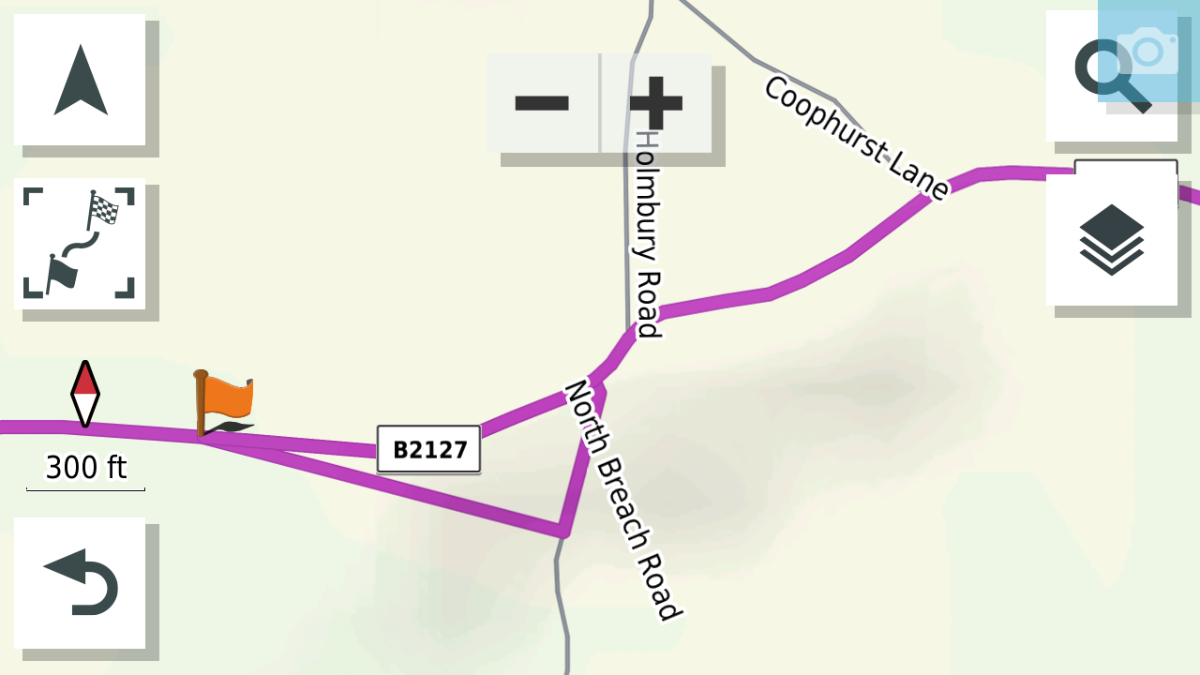
Two thing stood out. Both were 'Crazy Ivans' (have you seen 'Hunt for Red October' ? ) The route seems to go around a full loop of side roads before rejoining the original. I've yet to work out where it leaves the original and why.

First Loop Oddity
173696.png
173696.png (229.01 KiB) Viewed 903 times
Click to see the larger image. The Orange flag Via Point is 8 Ockley Road. The distance is negligable (see the scale). The triangle consists of two straight lines. There is a road (North Breach Road) where is leaves the (main) B2127 to head south but that appears to be plotted as a straight line. There is no road heading WNW - definitely plotted as a straight line. I loaded up the OSM maps of the area, and note that the Gramin plotted route deviates from the OSM roads at theis point. Not by much, but it may be that the maps are wrongly plotted. So I checked the track produced by Garmin and plotted it onto Ordnance Survey 1:25,000 (Hiking) maps - which have been extremely accurate when I plot my satnav riding logs onto them. The Garmin maps are correct.


2nd Loop Oddity
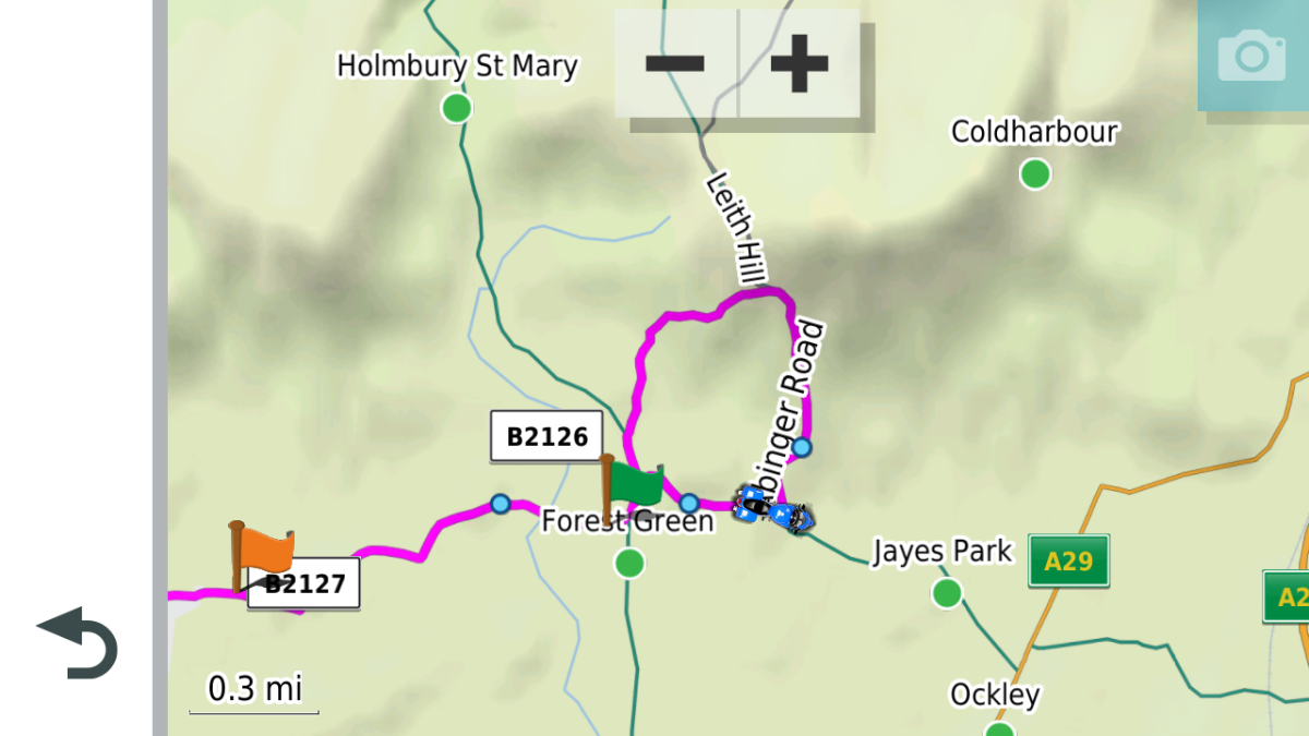
203210.png
203210.png (544.88 KiB) Viewed 903 times

Click to see the larger image.


This 'Crazy Ivan' is is just a little before. The green flag is where I had positioned the motorcycle for the navigation simulation. I joined the route by asking for the Closest Entry Point. It decided that the closest entry point was heading East, so it is navigating an anticlockwise loop to get to the Orange Via Point at 8 Ockley Road. It started at the green flag. I need to verify this behaviour - the XT will produce odd results if it thinks that you are facing in the wrong direction, and it can depend on whether or not you allow U turns. From Yorkshire, I have seen it calculate a route down to Northamptonshire, go around a roundabout and then head north again. A round trip of over 200 miles to get to a point that was half a mile up the road.

The XT calculates routes from point to point. If either of those points is not on a road that the XT map tells it is navigable, then the route between those two points will be plotted as a straight line. This often happens if the map used to create a route is different from the map that Zumo uses.


One final possibility is a fault that I have reported to Garmin. It is weird. I haven't pinned down the circumstances precisely, but it seems to happen after the XT has recalculated a route. If you subsequently deviate from the route (say at Point A), it seems to display similar characterstics like it would if you deviate from a track converted to a trip. In this case, this 'track-trip' stays put, but the XT will navigate you to the closest point on the original route.

Under certain circumstances - like if the closest point is behind you at Point A, it will calculate a route from where you are now (call it Point B), which involves turning round and going back to point A.

You ignore it. And carry on. The closest point now to the correct route is now at Point B. The XT seems to have modified the original route so it is now B to A to the end. You have just ignored it, so it issues another instruction taking you from C to B to A to the end.

And so on - and it may continue doing this until the actual closest point on the original route is ahead of you - and you are closer to that than you are to the last time that it asked you to turn round. You can have the situation where it is trying to take you on a 25 mile trip to get you to reach a point half a mile ahead.

My suggestions to cope with all of these:

Check the route created if you use Closest Entry. Makesure that the XT has you facing the correct direction. If not, start moving before actually pressing Go, so that it knows which way you are heading.
Load the track of the route as well as the route itself - display both. Any doubt, follow the track.
Beware of any instructions issued by the XT if you detour from a route that the XT has previously recalculated.
Consider turning off automtic recalculation.

I'm not done with this yet. I'm curious about the images that you showed, as I haven't been able to reproduce those. It might take some time, but it might halp me pin down the issues that I have reported to Garmin.
Have owned Zumo 550, 660 == Now have Zumo XT2, XT, 595, 590, Headache
Use Basecamp (mainly), MyRouteApp (sometimes), Competent with Tread for XT2, Can use Explore for XT - but it offers nothing that I want !

Links: Zumo 590/5 & BC . . . Zumo XT & BC