Page 1 of 1
Converting a track to a map
Posted: Wed Apr 13, 2022 12:54 am
by Random Dave
Hi Everyone, longtime lurker first time poster. Sorry if this has been asked before but I was not able to find it in a search.
I have run around our trail network out back a few times and built a nice track with all the trails and cut offs. How do I turn this into an overlay that is superimposed on the aerial view map I have uploaded? Maybe also adding in some notes and names?
Re: Converting a track to a map
Posted: Wed Apr 13, 2022 4:13 am
by jfheath
Hi Dave
Welcome to the forum.
You would need to Geo-reference the photo ie pin-point the precise location (lat, long) of a few selected, identifiable locations on the photo and then use software that would be able to use that to draw the image and the track together. I have some software that would do this, but I probably wouldn't do it like this.
It might be easier to use Google Earth to display the track - you would have to convert whatever format your track is stored (I assume GPX) into KML format and load it in. I think this would be the best option.
Or use Basecamp to display the track and download the Birdseye imagery.
Or download Birdseye imagery to the XT, and view the image on that.
A more primative method would be to display the track plotted on a very basic map and take a screenshot Identify and mark on the map the points which correspond to four points on the photo - the 4 corners would make the it a bit easier. Then use graphics software to paint out the unwanted markings on the map so that the track can be seen on a single coloured background. You can then superimpose the track on top of the map. The software would need to have the ability to distort the photo so that the four corners lie on top of the corresponding points that you marked on the map. (Or distort the map to match the 4 corners of the photo). The software would also need the ability to make the background colour of the map transparent
The problem is that although your photo of the ground is rectangular, the area that it covers is not.
Re: Converting a track to a map
Posted: Wed Apr 13, 2022 4:30 am
by Random Dave
Thank you, I will try the google map method. Once I get the track to show up as an overlay to the aerial photo I assume I can then upload it as a combined birdseye image to the Zumo?
Re: Converting a track to a map
Posted: Wed Apr 13, 2022 5:51 am
by jfheath
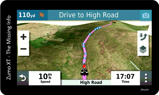
I don't think so. But why would you want to ? You can load areas of Birdseye imagery onto the Zumo anyway. That gives you overhead satellite view and also renders it as a 3d image. You can then load your route or track in the normal way.
But that isn't what you asked ( or I misunderstood ).
Hang on - I'll find a picture.
- 84027051-4351-4941-A36A-0B26F69B1B11.gif (62.9 KiB) Viewed 955 times
Re: Converting a track to a map
Posted: Wed Apr 13, 2022 6:09 am
by sussamb
Re: Converting a track to a map
Posted: Wed Apr 13, 2022 9:57 pm
by Random Dave
Perhaps I am explaining this wrong. I just want to turn this track into a semi-transparent layer that can be pasted over an aerial photo of the area that can be used as birds eye images in the gps. It needs some editing and I guess it would be nice if it could be something the gps recognizes as roads but i'd just be happy with a marked up map.
Edit: The area this track encompasses is about a hundred acres not counting that long tail on the left.
Re: Converting a track to a map
Posted: Thu Apr 14, 2022 5:20 am
by sussamb
If they exist as gpx tracks or routes then the program I mentioned above will create a transparent map for you.
Re: Converting a track to a map
Posted: Thu Apr 14, 2022 5:21 am
by jfheath
I wouldn't have a clue about how to do that.
I could get a semi-transparent track to show on a satellite image.
But how you get that onto the Zumo screen.....No. I don't know.
Theres a facility for custom maps, but I haven't got a clue how to use that either - although I have made my own georeferenced maps for other mapping software. Not navigable though.
Re: Converting a track to a map
Posted: Thu Apr 14, 2022 5:40 am
by Random Dave
sussamb wrote: ↑Thu Apr 14, 2022 5:20 am
If they exist as gpx tracks or routes then the program I mentioned above will create a transparent map for you.
Is it possible to edit it first? I have to get rid of some lines I accidentally created like the two straight grey lines on the right. I forgot to shut off the tracking then turned the unit on at home so it made a beeline right to the house. Not sure what the other one is pointing to but I'd like to get rid of those and a few other similar oopses.
Re: Converting a track to a map
Posted: Thu Apr 14, 2022 10:02 am
by Rofor
Yes, of course - take any program you like (e.g. Basecamp) and manipulate the track as you like - save or export it as .GPX file and use it with the program sussamb mentioned to create a transparent map...