Page 1 of 1
tracks to route conversion loses legs
Posted: Tue Nov 16, 2021 5:51 pm
by auke54
- XT screenshot
- 1109906.png (587.03 KiB) Viewed 662 times
Hello out there!
The case:
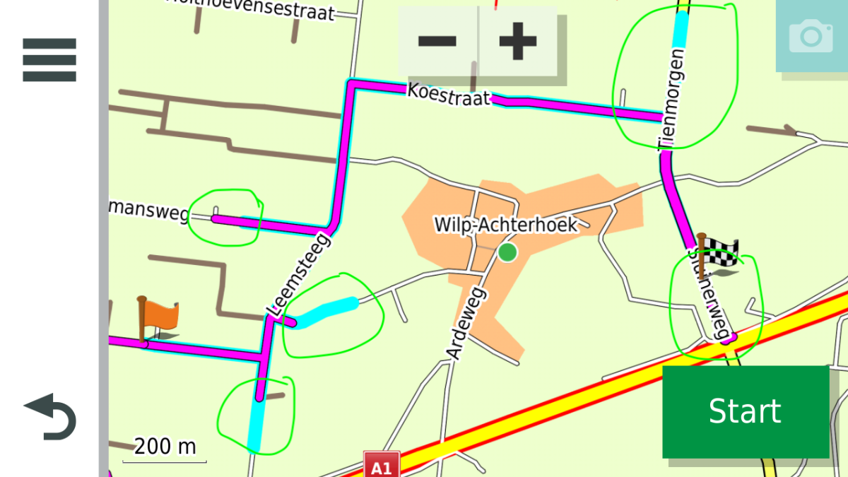
When a track that includes one or more ‘loose’ legs is converted to a route, the resulting route sometimes does not cover the entire sourcing track, or sometimes ‘does’ more than that.
A bit more info: I do exchange routes and tracks-from-those-routes with my fellow riders. Sometimes we run into issues. One of the things we do to keep control is load the track-from-route that was created in BaseCamp into the XT and convert that on the XT to a route. Then we navigate on this route, meanwhile let the track be visible peeping a cyan band from under this route.
Last weekend I ran into a surprising issue. I knew that it should navigate me to a certain restaurant but instead it passed along, letting the cyan line, which pointed to the right spot, go. Hmm, that made me wonder.
I managed to make up a test situation which reproduced this kind of behaviour. And yes, I also noticed Garmin Support about this(by email).
The GPX of an example track and the XT screenshot showing both track(cyan) and route(magenta) are attached. Please note the differences in the picture.
Zumo XT:
• SystemSoftware 6.30
• Maps: CN EU NTU 2022.20
• Settings => Navigation:
• Calculation: Faster time
• Avoidances: Unpaved Roads
Any idea?
Re: tracks to route conversion loses legs
Posted: Thu Nov 18, 2021 9:46 am
by jfheath
I know this is an old thread and you may have your answer. I was just looking through posts that have received no replies.
This is one of those problems where the solution really requires you to start with a completely different set of circumstances.
How did that track end up with so many detours up side roads ? It looks as though someone has made a route with not very well placed shaping points and then converted it into a track.
Anyway - that aside, to answer your question
A track requires hundreds - sometimes thousands of points in order to make sure that the straight line that is drawn between each individual point follows the roads correctly. So that it look as though it is made with straight lines at all.
A route needs only a few fixed points and the routing software takes care of what happens between those points.
When a track is converted to a route, the software will often 'decimate' or sample the number of points. (eg remove every 10th point; remove every other point; remove 9 points out of 10) In programs like Basecamp, you can specify how many points to sample from the original track. I have seen reference recently that one such process (either on the XT or in Explore) will keep only 200 points when it receives a track. (Not the first 200 - it will sample them - so if there are 1000 points in total, it will keep only every 5th point)
That means that some of the points of the original track will not be included in the route. Mostly, you will not notice this because the routing software will fill in the gaps quite sensibly. But if the missing point was one that was stuck out on the end of a dead end, then yes, you will notice that it has disappeared.
But the XT has no function for converting a track to a route. It has a facility for turning a track into a 'trip'. An odd name, since Garmin use the same word for something else. It is like a route, but does not behave in quite the same way.
Re: tracks to route conversion loses legs
Posted: Fri Nov 19, 2021 12:21 pm
by auke54
Hi
Thanks for your remark jfheath!
The example is a fabricated situation to reproduce the issue, so no real life trip/track.
In the real trip there are not that much occurrences and they are surely not that close(only 2 over the 400 km ride). And, I must say, till this weekend I also did not care much and took very little notice. But, they were there, as a blue 'spike' in a right angle on the routeline.
But now, having the time, I looked into it.
I have noted your remarks about the sampling. I have to give it a bit more thought, maybe a new idea comes up.
Or, Garmin has something nice to mention.